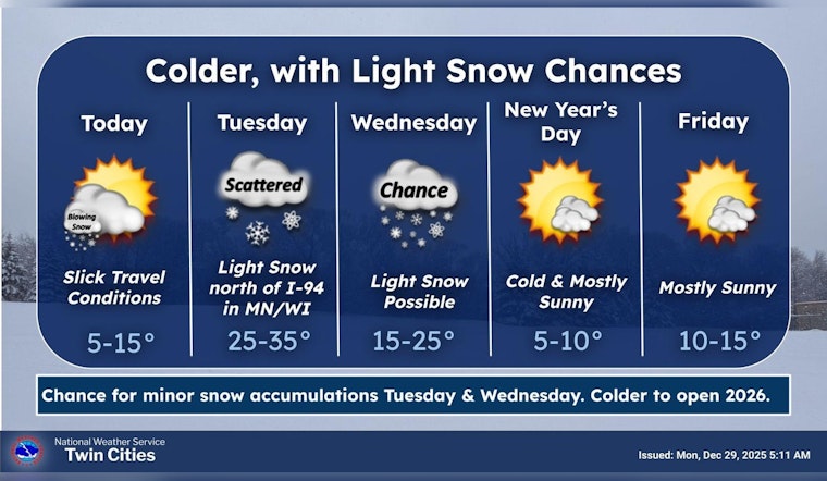
The National Weather Service has issued a stern reminder for Twin Cities residents: the aftereffects of the recent snowstorm are lingering and pose a real threat to the safety of those braving the roads. Intermittent blowing snow before 8 a.m. and a frosty high of 12 degrees have been forecasted for Minneapolis today, with conditions remaining blustery. "Blowing snow and slippery roads will contribute to continued hazardous travel conditions," according to the National Weather Service forecast. The advisory stresses that even though the direct snowfall from the recent storm has subsided, winds persistently churning up snow have the potential to reduce visibility and create slippery conditions.
One can expect to see a 20 percent chance of additional snowfall after 5 a.m. tonight. The frigid temperature, set to drop to around a low of 3, compounds the risk for both motorists and pedestrians alike. Meanwhile, the forecast for Tuesday brings a 30 percent chance of snow, mainly before 9 a.m., with mostly cloudy skies and a high near 31. "Please refer to the Winter Weather Advisory for additional details," states the Hazardous Weather Outlook. Despite the slight uptick in temperature, caution remains paramount as conditions remain unpredictable.
Extending into the week, Wednesday pushes the envelope on the chill factor, with a forecasted 40 percent chance of snow mainly before noon, whereas New Year's Day promises mostly sunny weather but with a high barely reaching 9 degrees. The weather for the rest of the week oscillates, with mostly sunny skies giving way to cloudier nights, and temperatures fluctuating between evening lows around -2 and daytime highs approaching 18 degrees. This pattern is consistent with the reality of Minnesotan winters, where a semblance of peace often precariously sits atop the next frigid wave.
It's not just drivers who should stay alert. The winter weather advisory remains in effect until 6 PM CST this evening, underscoring the potential for "roads, and especially bridges and overpasses," to be "slick and hazardous." The advisory, which includes a wide area "of central, east central, south central, southeast, southwest, and west central Minnesota and northwest and west central Wisconsin," advises travelers to "use caution while traveling, especially in open areas," as delivered via the advisory. While the bulk of the storm has moved on, it's clear that its residual clout holds should be enough to warrant caution through Monday's commutes and beyond.


