The snowstorm that hit Northeast Ohio and Northwest Pennsylvania is leaving residents bracing for additional inches of snow and bone-chilling cold. The National Weather Service in Cleveland updated the forecast early this morning to reflect the increase in snowfall, with an additional 1-3 inches expected across the snowbelt areas. The report also warns of dangerously low wind chills that could plummet to -25 degrees Fahrenheit tonight into Tuesday morning.
The upgraded Extreme Cold Warning now in effect spans the entire region until 11 AM Tuesday, according to NWS Cleveland. This severe weather is the result of cold air over lake effect snow and an upper-level trough moving across the Great Lakes. The ongoing snowfall has made travel conditions hazardous, with snow-covered roads posing issues, particularly in the Cleveland-Akron metro area.
Adding to the concern is Tuesday's forecast, which anticipates a clipper bringing more snow across the area. The expected light snow accumulations and breezy conditions could hinder travel with patchy blowing or drifting snow. For those in Northeast Ohio and Northwest Pennsylvania, per the NWS discussion, an additional 1-3 inches of snow could spell minor travel disruptions.
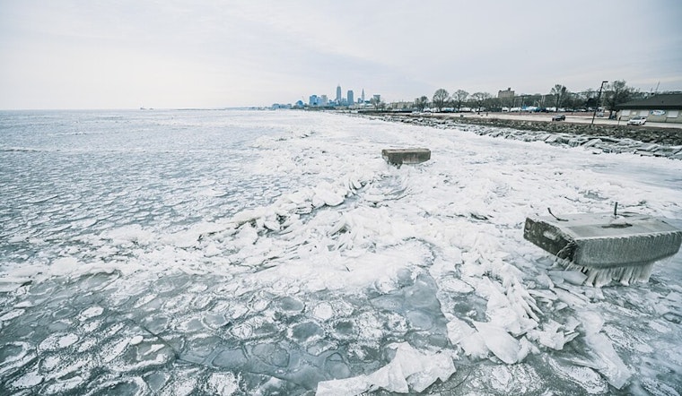
With the deep cold set to persist through the weekend, the risks of frostbite, hypothermia, and infrastructure damage are elevated. The recent snowstorm has already set the stage for below-zero air temperatures, which are anticipated to keep a grip on the Great Lakes region. Potential issues include burst pipes, dead car batteries, and a heightened risk of carbon monoxide poisoning or structure fires, as people turn to alternative heat sources. Lake Erie, now 92% ice-covered, is expected to see even thicker ice formation in the coming days, a detail not lost on local authorities and the National Weather Service's latest advisory.
On the aviation side, improvement is on the horizon for some Ohio airports, with drier air moving in to end lingering snow effects. However, the evolution of weather conditions will continue to demand attention as another clipper system is expected to bring snow showers and decreasing visibility by Tuesday morning. The NWS Cleveland aviation forecast indicates that non-VFR conditions are likely to remain a concern through Friday, particularly in areas downwind of Lake Erie.
NWS Cleveland's marine forecast notes that with Lake Erie largely ice-covered, the shifting winds in the coming days might cause existing ice to move, especially given the stronger southwest winds expected. This wind pattern could impact the thickness and stability of the ice, with numerous implications for marine activities and coastal conditions. Residents and mariners alike in the region will need to stay abreast of conditions and heed the warnings issued. As the cold tightens its grip, preparedness remains paramount.


.jpg)