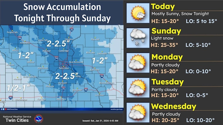
Minneapolis woke up bitterly cold, with temperatures near 1°F at Minneapolis–St. Paul International Airport, but the deep freeze will not last. A quick Alberta clipper is on track to swing through late Saturday night into Sunday, bringing a light burst of snow that could turn the morning drive into a slow crawl. Saturday is expected to rebound into the mid-to-upper teens before a south wind picks up and clouds thicken in the evening. The main impact looks to be light, accumulating snow overnight and into Sunday morning, enough to slow commutes. Forecast totals remain modest, from a light coating up to 2 inches, with a few isolated pockets potentially reaching around 2.5 inches.
What to Expect Tonight Into Sunday
Snow is expected to move in after midnight Saturday, become steadier toward sunrise Sunday, then gradually taper by Sunday afternoon. New snow totals of 1 to 2 inches are likely across the metro, with localized higher amounts and a slight chance of brief freezing drizzle during transitions, according to the National Weather Service Twin Cities/Chanhassen. Temperatures should hold in the mid-teens Saturday night, climb to around 30°F on Sunday, then drop back into the 20s later in the day.
Commutes, Sidewalks And City Rules
Drivers should plan for slick spots Sunday morning, particularly on bridges and untreated side streets, and build in extra time to ease off the gas and adjust for changing conditions. City rules still apply, even for a light event. Property owners must clear sidewalks within 24 hours after a snowfall, and non-single-family properties have only four daytime hours to get it done. The city also offers free sand at neighborhood sites to help improve traction. Check the City of Minneapolis for sand locations and any snow-emergency guidance.
Weekend Planning
For outdoor plans, Saturday afternoon is your best bet, with the driest and sunniest conditions before the late-night snow arrives. Sunday could turn slushy later in the day as temperatures hover in the 20s. Looking ahead, forecasters expect a slight warm-up next week, with highs returning to the 20s and 30s, giving road crews and shovelers a better window to catch up. This forecast may be updated if any heavier snow bands develop or if the timing shifts.


