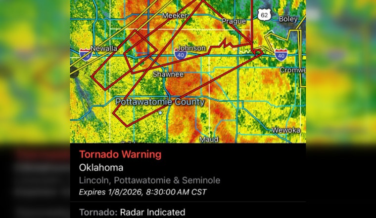
A grave weather condition has triggered a tornado warning across several counties in central Oklahoma. According to the National Weather Service from their update at 7:57 AM CST today, areas within northwestern Seminole, south central Lincoln, and northern Pottawatomie counties are under imminent threat until 8:30 AM CST, as disseminated by the Pottawatomie County Emergency Management via Facebook post.
With the severe thunderstorm spotted just 4 miles northwest of Brooksville at the time of the alert, and was tracking its way northeast at an alarming speed of 60 mph. It paused, the threat of a tornado intensifies as the National Weather Service has reported "radar indicated rotation." For all those in its potential path, the peril is real; flying debris could harm those without proper shelter, and significant damage to mobile homes, vehicles, and buildings is likely, especially their roofs and windows, as reported by the Pottawatomie County Emergency Management.
Communities bracing for this storm's wrath include Shawnee, Tecumseh, Johnson, Brooksville, Bethel Acres, and Centerview, as detailed by emergency management authorities. This tornado warning also comprises a section of Interstate 40, marking a treacherous stretch between mile markers 184 and 204 where travelers ought to exercise extreme caution or avoid completely until the danger has passed.
For those seeking safety, the message from authorities is clear: "TAKE COVER NOW!" The Pottawatomie County Emergency Management officials are advising that affected residents move to a storm shelter, safe room, or an interior room on a sturdy building's lowest floor, a guidance that is echoing across social media platforms as well. They also recommend evading windows and – if one finds themselves outdoors, in a mobile home, or inside a vehicle when the storm hits – they should seek out the nearest substantial structure for protection against flying debris, which can be life-threatening. The indicated maximum hail size accompanying this weather phenomenon is less than .75 inches.
Regular updates and advice are available online as the situation develops. To stay abreast with real-time information and safety advisories from Pottawatomie County Emergency Management, individuals are encouraged to follow their Facebook page.


