San Antonio is starting today on a clear and biting note, with an early 4:55 a.m. observation showing temperatures just above freezing at about 34°F. Clouds are expected to roll in through the morning, and the city should rebound quickly into the upper 60s by afternoon, a sharp turnaround after a cold weekend.
Afternoon Warm-Up and Weak Front on the Way
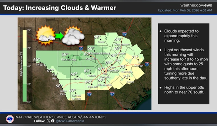
Monday’s forecast calls for a high near 67°F, mostly cloudy skies, and light southwest winds around 0–10 mph. A weak cold front sliding through on Tuesday could stir up a few showers, mainly along and east of the I-35 corridor, although rain chances in the city itself remain low. According to the National Weather Service, humidity will creep up a bit ahead of that front.
Fog Threat Could Snarl Tuesday’s Early Drivers
That higher humidity Monday night may set the stage for patchy to locally dense fog before dawn on Tuesday, trimming visibility on surface streets in parts of the metro. Early commuters are advised to budget extra time and stick with low-beam headlights, and brief flight delays at SAT are on the table while low clouds hang around. Local forecasters tracking the hour-by-hour setup are highlighted by MySanAntonio.
Cool Dip, Then a Springlike Late-Week Stretch
The weak front is expected to knock temperatures down briefly on Wednesday, with lows dipping into the upper 40s, before a building ridge nudges readings back up later in the week. Highs should return to the mid-60s on Thursday and climb into the mid-70s by the weekend, with a few inland spots flirting with 80. There are currently no watches or warnings in effect for the San Antonio area, so residents with outdoor plans are encouraged to keep an eye on updated official forecasts as the week unfolds.


