Downtown Los Angeles woke up Monday, February 16, 2026, to a soggy start: steady rain, gusty south winds and temperatures parked in the mid 50s as bands of showers and isolated thunderstorms pushed through the basin. City crews are already flagging slick streets and rising stormwater in low-lying neighborhoods.
What To Expect Today
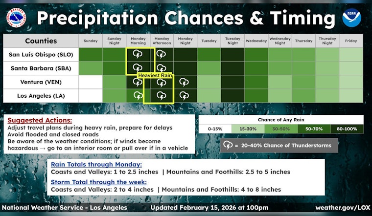
Forecasters expect periods of heavy rain on and off through Monday, with the main frontal passage during daylight hours and a continued risk of thunderstorms. A Flood Watch is in effect from 9 a.m. to 9 p.m. Monday, February 16, 2026, with coastal and valley areas projected to pick up roughly 1 to 2 inches of rain, while coastal slopes and foothills may see 2 to 4 inches. Those totals are enough to raise concerns about flash flooding and burn-scar debris flows, according to the National Weather Service.
South to southwest winds will stay gusty and brief but intense downpours are likely at times, making for some messy commutes and slowing traffic across much of the city.
Afternoon Commute And Coastal Hazards
Drivers should plan on slower travel, pooled water on low-lying streets and the usual mystery splash from that one badly graded intersection. Do not attempt to drive through flooded roadways, no matter how shallow they look from behind the wheel.
South winds will commonly gust in the 25 to 35 mph range, with stronger blasts in exposed canyons and passes. Out at the shore, west-facing beaches are in for large surf and elevated tides through the week. Before you head out, check for operator alerts on transit and ferry services in case weather trims schedules or reroutes lines.
Mountains And The Grapevine
Snow levels will start out relatively high, then drop into the 4,500 to 6,500 foot range at times. That sets the stage for periods of heavy, wet snow above the passes and potentially slushy conditions on Interstate 5 over the Grapevine Tuesday night into Wednesday, February 17 to 18, 2026.
Anyone planning mountain travel should be ready for chain controls, reduced visibility and sudden closures. Check Caltrans and CHP updates before you hit the road. Resorts above about 6,000 feet could see significant snow accumulations out of this system.
Safety Notes
If you live below recent burn scars or in a flood-prone neighborhood, have an evacuation plan ready and be prepared to move to higher ground if local officials recommend it. Secure loose outdoor items, avoid walking or driving through floodwater and keep phones charged so you can receive alerts and emergency instructions.
We will update this post if additional watches or warnings are issued.


