Phoenix is serving up more June than February this Monday with clear skies, mild morning air near 57°F, and relative humidity hanging in the low 40s. By this afternoon, the sun is expected to drive highs into the mid‑80s, around 84°F, making it one of the warmest days of the month. Winds stay light, so most neighborhoods can expect a dry, bright day with overnight lows settling into the mid‑50s.
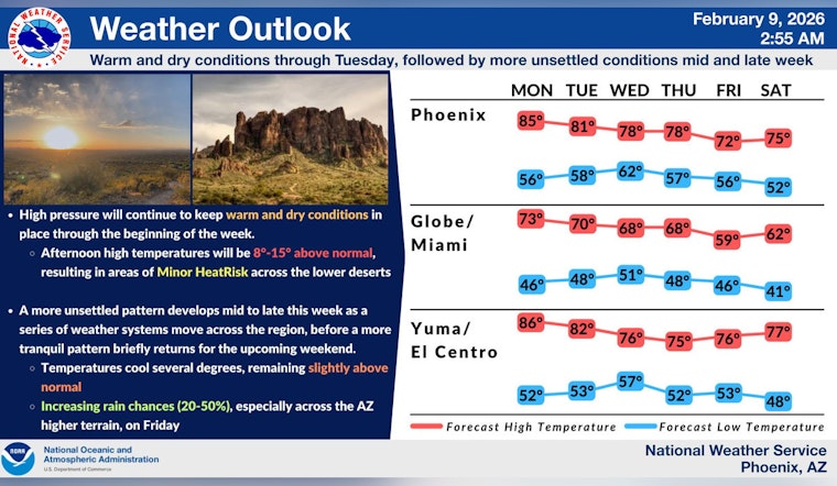
Afternoon Heat Through Tuesday
Forecasters are calling for highs near 84°F today and around 79°F on Tuesday, keeping much of the lower desert under a Minor HeatRisk for people who are sensitive to warmer conditions, according to the National Weather Service Phoenix. The agency advises staying hydrated and grabbing shade breaks if you are outside for long stretches. With humidity staying low this afternoon, it is smart to schedule the heaviest work or workouts for the coolest parts of the day.
Late‑Week Cooldown And Spotty Showers
A mid‑to‑late‑week trough is expected to knock daytime highs back into the 70s by Friday and introduce a slight chance of spotty showers over higher terrain from Thursday night into Friday. Any measurable rain should mainly favor areas east of the Valley, while Phoenix itself is likely to stay mostly dry. The weekend looks quieter and a bit warmer again before another system may nudge rain chances back into the forecast early next week.
Stay Comfortable Outdoors
If you are planning to be outside, keep water handy, wear a hat, and aim longer outdoor chores or activities for the morning or evening to dodge the warmest hours. For those who need air‑conditioned relief, the city maintains cooling centers and hydration stations around town; locations and hours are listed on the City of Phoenix cooling centers page. No watches or warnings are currently in effect for Maricopa County, but it is still worth checking the latest forecast before heading out for any evening plans.


