State transportation officials say the study team looking at the I‑90 ramps at Rainier Avenue South has landed on a recommended layout aimed at making things safer and smoother for people heading to the new Judkins Park Link station. The concept would remove one westbound ramp, slim Rainier under I‑90 down to four lanes, and carve out space for a dedicated bus lane plus protected walking and biking routes.
The milestone surfaced on X via WSDOT Traffic, while the long-running study itself is broken down in detail on WSDOT’s project page, which outlines the timeline, advisory group and the grants that paid for the planning work. Officials are pitching the redesign as a way to put people walking, rolling and riding transit first, while still keeping access to nearby businesses in play.
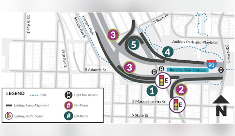
What Alternative 2 Would Change
In a blog write-up, WSDOT names Alternative 2 as the preferred option and spells out what it includes: closing the westbound I‑90 to northbound Rainier off-ramp (Ramp 4) and sending that traffic to Ramp 5 instead, adding a new pedestrian signal north of I‑90, and cutting Rainier from six lanes to four. That would leave one general vehicle lane and one dedicated bus lane in each direction so there is room for protected bike lanes and wider sidewalks. According to WSDOT's blog post, Alternative 2 came out on top for safety and access after traffic modeling and community feedback.
Why Officials Say It Helps
Agencies say the redesign is intended to slow drivers as they turn where ramps meet the street, cut down the time people are exposed to fast traffic and help buses keep to more reliable schedules. The City of Seattle has already put in some early safety upgrades, including raised crosswalks at three ramp crossings, and plans to add rapid-flashing beacons in spring 2026, according to the Seattle Department of Transportation.
What Happens Next
WSDOT says the study team will spend this spring and summer working with SDOT, King County Metro, Sound Transit and federal partners to fine-tune Alternative 2, wrap up study documentation and develop preliminary 30 percent design with the help of the advisory group. The agency also notes that the study is only funded through early design, with about $3 million in planning grants, and that construction money still has to be found. More details and sign-up information are available on the study page.


