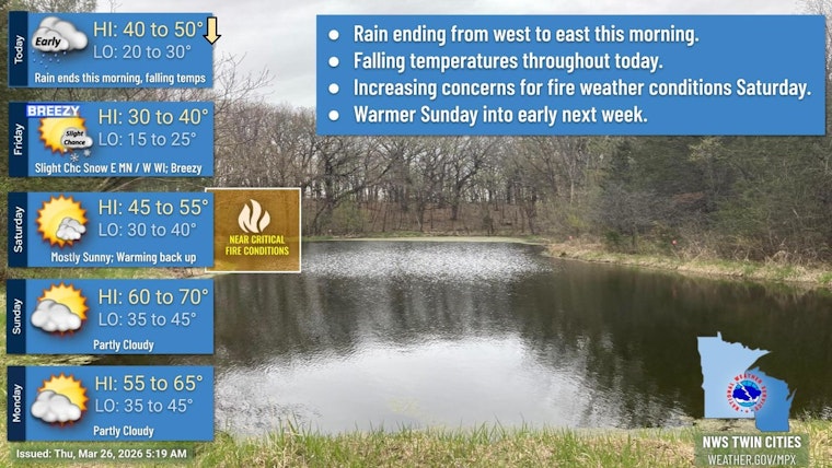
Thursday, March 26, 2026, is starting on a gray, soggy note across Minneapolis, with clouds parked over the city, temperatures in the upper 40s to low 50s, and light rain sliding through the region. Showers look most active during the morning commute before they ease by late morning as a colder northerly flow settles in. North winds will keep afternoon highs stuck near the upper 40s, making it feel noticeably cooler compared to the recent milder stretch.
Morning Commute: Light Rain Through Mid-Morning
Rain is expected through roughly 11 a.m. on Thursday, March 26, with only light totals on tap. Most spots should see less than a tenth of an inch of rain, but low clouds, wet pavement, and brief dips in visibility could make for slick roads during peak drive times, so give yourself extra room to brake. This timing and light precipitation outlook comes from the National Weather Service.
Afternoon Chill and Gusty North Winds
Temperatures will peak near 49°F before slipping back into the mid-40s later in the afternoon as north winds increase to 10–15 mph with gusts around 20–25 mph. Those gusts could create noticeable crosswinds on bridges and other exposed roadways, and operations at MSP may deal with stronger crosswinds during the midday hours. The National Weather Service Twin Cities also highlights a cooler follow-up on Friday, with the potential for stronger gusts at times.
Weekend Outlook
After today’s chill, temperatures rebound over the weekend. Highs climb to around 54°F on Saturday and reach near 68°F on Sunday. Forecasters are already eyeing a different concern for Saturday afternoon: dry air combined with southwest winds could set up critical fire-weather conditions across parts of southwest Minnesota. If you have any outdoor burning on your to-do list, check current fire restrictions and be ready to postpone if officials issue guidance. Keep an eye on updated forecasts later in the week for more precise timing and locations of any elevated fire-risk alerts.
What To Do Today
For today’s travel, grab a rain jacket, give yourself a little extra commute time, and secure lightweight outdoor items ahead of the gusty north winds. If you’re flying, double-check with your airline and MSP airport updates before heading out. For the latest official forecast details and any watches or warnings, rely on the National Weather Service Twin Cities resources linked above.


