Ten years after President Barack Obama invoked the Antiquities Act to create Sand to Snow National Monument, the 154,000-acre stretch from desert washes to the snow-capped summit of San Gorgonio still feels, to many locals, more like a line on a map than a fully realized destination. In Desert Hot Springs, city leaders say there are no monument signs to greet visitors, no formal visitor center and little of the promotion or basic infrastructure that usually follows a new federal designation, even as nearby parks are bursting at the seams.
“It has been, quite frankly, 10 years of nonaction,” Desert Hot Springs Councilmember Gary Gardner told reporters. As reported by SFGATE, Gardner and other officials say drivers on State Route 62 can pass straight through without any hint that a national monument is nearby, and the town still has no brochures, kiosks or staffed entry point to stake its claim as a gateway community.
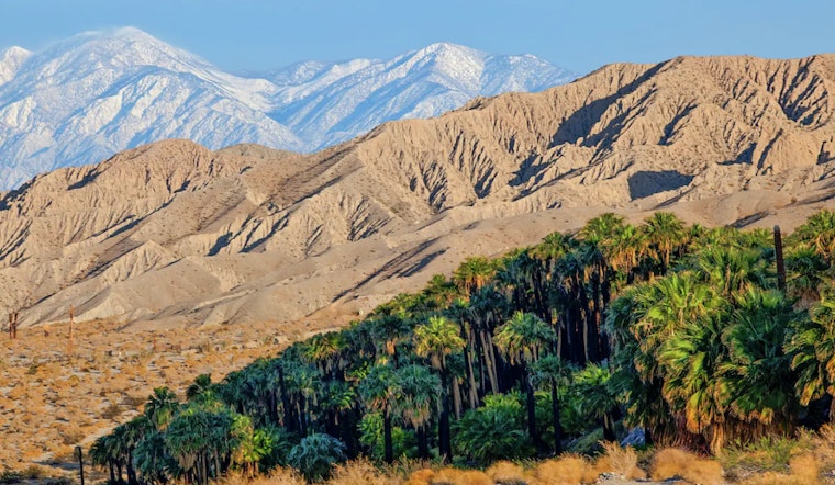
What Sand to Snow protects
By presidential proclamation on Feb. 12, 2016, President Obama set aside the Sand to Snow landscape to conserve a dramatic climb in elevation and cultural resources, according to the White House. The Forest Service describes the monument as roughly 154,000 acres, co-managed by San Bernardino National Forest and the Bureau of Land Management. It includes the 11,503-foot summit of San Gorgonio, about 30 miles of the Pacific Crest Trail, an estimated 1,700 Native American petroglyphs and roughly a dozen threatened or endangered species. U.S. Forest Service materials outline those protected features and the ecological connectivity the designation was intended to secure.
Why there is still no management plan
The proclamation instructed the U.S. Forest Service and the Bureau of Land Management to craft a joint management plan. That assignment has dragged on. The Forest Service formally folded the proclamation into its broader land-management plan in June 2021 and announced that the agencies "will next work on the development of a monument management plan" but that "no dates are currently set for that process," according to a Forest Service news release. Local advocates and subsequent reporting point to uneven federal attention in the years since designation, which has complicated efforts to pull everything into one comprehensive plan. SFGATE noted that some community members and conservation backers remain worried about staffing levels and follow-through.
On-the-ground work, visits and staffing
Despite the lack of an overarching plan, on-the-ground work has continued in fits and starts. The Bureau of Land Management’s FY2023 manager’s report estimates that roughly 340,000 people visited the monument in 2023 and details recent staffing additions that supported outreach and volunteer projects. The same report chronicles storm and trail damage that led to road closures and shut down segments of the Pacific Crest Trail, while also spotlighting partner groups that helped with trail repairs, visitor education and cultural interpretation. Bureau of Land Management documents provide the most recent snapshot of visitation and operations on the ground.
Partners have filled some gaps
Much of the monument’s backbone took shape long before the presidential proclamation. The Wildlands Conservancy spent decades acquiring and managing key private preserves that now serve as de facto trailheads and stewards at Whitewater, Mission Creek and other access points. Those preserves and subsequent land transfers helped stitch together habitat linkages that made the national monument proposal viable in the first place, and they continue to deliver visitor services and education at a scale federal agencies have struggled to match. The Wildlands Conservancy describes that campaign and the preserves it still manages.
Desert Hot Springs wants a gateway role
Just down the road, Desert Hot Springs has been trying to claim the “sand” side of Sand to Snow. The city has leaned into its historic mineral-spring identity while courting outdoor-oriented visitors, rolling out a spa revitalization incentive program and city trail materials that it hopes will draw hikers and road-trippers. City documents list the Spa Revitalization Incentive Program and map local hiking routes that officials say could anchor a proper visitor hub if federal agencies followed with basic signage and interpretive investments. City of Desert Hot Springs materials outline the municipal push to marry spa culture with nearby public lands.
As Sand to Snow enters its second decade, agency reports, local officials and conservation groups all point to the same tension. The landscape is legally protected and increasingly visited, yet there is still no unified and fully funded management blueprint. Federal agencies and partner groups cite ongoing coordination and project work, while Desert Hot Springs leaders keep pressing for relatively simple fixes like signs, kiosks and clear visitor information that often unlock economic benefits for gateway towns and improve stewardship at the same time. How quickly the Forest Service and Bureau of Land Management set a public timeline for a joint monument plan will likely determine whether Sand to Snow becomes an obvious pressure valve for overcrowded Southern California parks or remains a quiet refuge that many people only ever see on a map.


