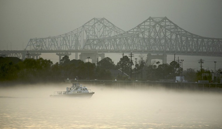
Dense fog rolled into parts of the New Orleans metro early Thursday, March 26, chopping visibility and slowing the morning commute. Temperatures are sitting in the mid‑60s with nearly saturated air, a setup that favors pockets of locally dense fog across low‑lying neighborhoods. Drivers can expect sudden drops in visibility near bridges, the lakefront and along the river parishes until the fog finally lifts later in the morning.
Morning Fog And Commute
A Dense Fog Advisory is in effect for portions of the metro through 10 a.m. CDT, with visibility dropping to one‑quarter mile or less in spots. Motorists are urged to slow down and stick with low‑beam headlights. Forecasters report that many terminals are dealing with low ceilings or reduced visibility this morning, while New Orleans International (MSY) has been less affected than some River and Bayou airports. Road cameras are catching increasing mist along the I‑10 Bonnet Carré corridor, so anyone using cross‑spillway routes should plan on extra travel time, according to the National Weather Service New Orleans/Baton Rouge.
Sunny Afternoons, Heat Returns
As the sun climbs, it should burn off the low clouds and fog, leaving a mostly sunny afternoon with highs near 81°F across the metro and only a slight cool‑down into the evening. Above‑normal warmth sticks around into Friday, when mid‑80s are possible and forecasters say temperatures may flirt with late‑March record highs.
Saturday Wind And Fire Risk
A weak front is expected to move through Friday night, ushering in much drier air and stronger northerly winds on Saturday. Sustained winds of 15–20 mph with gusts up to 35 mph are possible, and afternoon relative humidity could dip into the mid‑20s to near 30 percent north of the I‑10/12 corridor. That combination raises concern for critical fire weather across parts of the area. Anyone planning to burn yard debris or use outdoor equipment should be prepared to hold off and follow any local burn restrictions. For the full technical discussion, see the NWS forecast discussion.
Marine And Boater Notice
Coastal waters will see a short stretch of elevated winds on Saturday, enough for Small Craft Advisory conditions in many local zones, so boaters should secure loose gear and check local marine forecasts before heading out. Winds are forecast to relax by late Sunday as onshore flow returns, but choppy conditions are likely during the advisory window.
Looking Ahead
Little measurable rainfall is expected through the weekend, with showers and a chance of thunderstorms returning early next week. Coverage looks spotty with modest totals. Stay tuned to updates from the National Weather Service, as timing and local impacts can still change.


