Iberville Parish officials are sounding the alarm as a midweek storm system lines up to move through after dark, with the potential for isolated severe thunderstorms Wednesday evening into the overnight hours. According to the parish advisory, these storms could bring damaging wind gusts, hail, isolated flash flooding and even a few tornadoes. Residents are being urged to stay weather-aware and to make sure they have multiple ways to receive alerts while they sleep.
The warning went out on the parish’s official Facebook page Tuesday afternoon, where officials said the National Weather Service is monitoring the system and that storms are expected to move into Iberville Wednesday evening and continue overnight into early Thursday. The parish said it will keep pushing out updates as the forecast evolves and encouraged people to stick with official outlets for accurate information, per Iberville Parish Government.
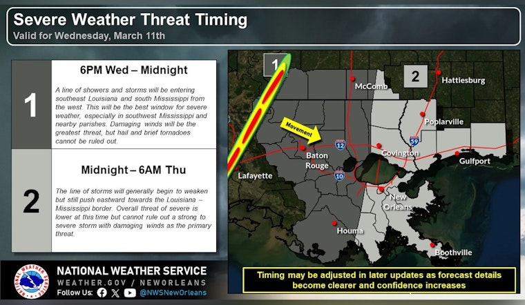
When the storms are expected
Point forecasts from the National Weather Service for the Baton Rouge and Iberville area show rain chances ticking up Wednesday night, with the main action expected after sunset and lasting into the overnight hours. Nearby point forecasts call for “showers likely, then showers and possibly a thunderstorm after 10pm,” a clear sign that the worst of it may arrive while many people are already in bed, according to the National Weather Service.
Threats to watch
The parish advisory highlights the main hazards on the table: strong, potentially damaging wind gusts, hail, a few tornadoes and the chance for isolated flash flooding. Officials are asking residents to check on family and neighbors who might need help, tie down or bring in loose outdoor items before the storms arrive and steer clear of low-lying roads during heavy downpours, according to Iberville Parish Government.
How to prepare
Local officials and forecasters are urging residents to tackle a few basics ahead of time. That means charging phones and power banks, making sure people and pets are indoors before storms fire up, moving vehicles out of spots that tend to flood and identifying a safe interior place to shelter from high winds. The National Weather Service also recommends turning on Wireless Emergency Alerts and keeping a battery-powered NOAA Weather Radio nearby. Through the night, residents are encouraged to monitor local media and official parish channels in case watches or warnings are issued.


