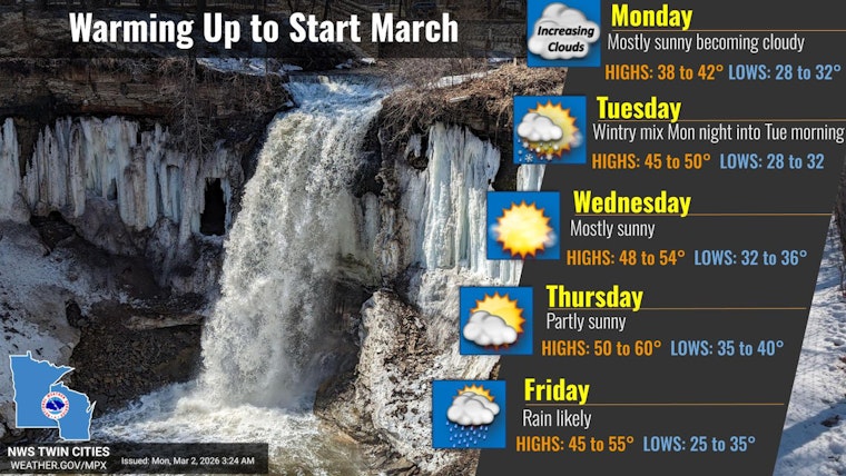
As of 5:35 a.m. CST Monday, March 2, the Twin Cities were sitting clear and chilly at about 23°F at Minneapolis-Saint Paul International Airport, with south winds starting to tug milder air into the metro. Expect mostly sunny skies today with a high near 42°F and south-southwest winds around 5 to 10 mph. The week trends milder overall, but a small system passing to our south could throw a quick shot of drizzle our way and a narrow window of freezing drizzle before sunrise Tuesday.
Tonight Into Tuesday Morning
Clouds build back in on Monday night, and temperatures only dip to around 33°F. A slight chance of drizzle develops in the pre-dawn hours, roughly between 3 and 4 a.m., with a small window for freezing drizzle before 7 a.m. Tuesday across the southern parts of the metro. Any ice buildup should stay light, but it may be just enough to put a thin glaze on untreated roads and bridges, turning the early commute into a bit of a surprise skating rink. Keep an eye on updates from the National Weather Service Twin Cities if you will be out early.
Midweek Warmup
Once we are past the early Tuesday slick potential, temperatures climb nicely through midweek. Highs reach near 49°F on Tuesday, about 52°F on Wednesday, and push into the mid 50s by Thursday. A stronger system then moves in and boosts rain chances late in the week. Rain looks most likely on Friday, setting up a soggy start to the weekend, with a brief rain and snow mix still possible early Saturday. For the earlier breakdown of the warmup, check out from teen temps to slushy streets.
Plan For The Commute
If you have early plans on Tuesday, build in some extra time and take it slow over bridges and overpasses where that light glaze can form first. The National Weather Service Twin Cities also notes that clouds will probably spoil views of the lunar eclipse early Tuesday morning, March 3, 2026, so sky watchers are likely out of luck. Check in with the National Weather Service before you head out for the latest timing and any forecast changes.


