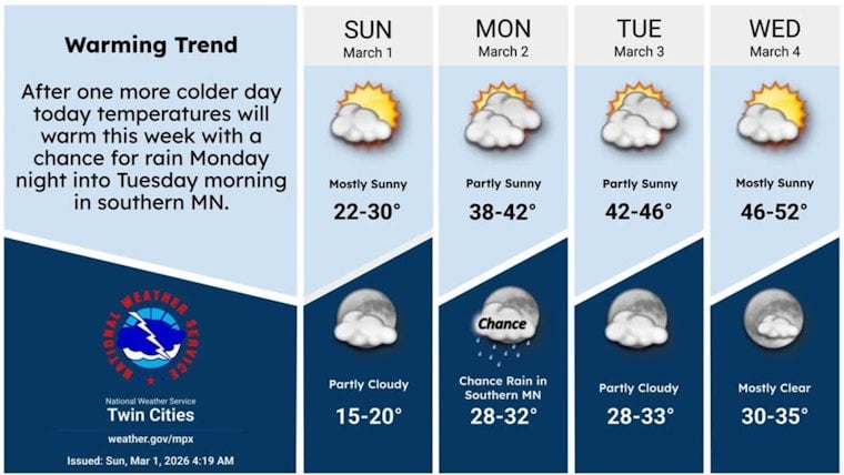
Minneapolis woke up under a blanket of clouds and a teeth-chattering 16°F early Sunday, but some timely sunshine should nudge afternoon highs into the upper 20s. With light winds on tap, the midday drive looks mostly quiet and dry. The real headline is the fast warmup on deck, with highs climbing above freezing Monday and an outside shot at the 50s by midweek.
Afternoon Through Tonight
Skies are expected to turn sunny this afternoon, with temperatures topping out near 29°F and a gentle east breeze of around 0 to 5 mph. Tonight brings partly cloudy skies and a low near 21°F. According to the National Weather Service Twin Cities, there are no active watches or warnings for the metro, so any widespread travel problems today are unlikely.
Midweek Warmup And What It Means
Temperatures jump quickly on Monday, with highs near 41°F, then settle into the 40s and even low 50s from Tuesday through Thursday. The warmest readings are expected on Wednesday and Thursday. That kind of rapid warmup will speed up snowmelt, so plan on slushy sidewalks, wet roads, and the usual early-season pothole surge, especially in spots where the snowpack is already thin. An earlier update from Feb. 15 flagged the same general pattern, and this latest forecast sharpens the timing while nudging those midweek highs a bit higher.
Late-Week Rain Chances
Rain chances stay on the low side through Tuesday, then start to tick up later in the week, with a modest chance by Thursday night and the best odds for measurable rain arriving Friday. With temperatures expected to hold at or above freezing across most of the metro, any precipitation should fall as rain rather than snow. That lowers the risk of significant new snow accumulation but raises the chance of extra runoff and messy, slushy conditions. Keep an eye on the National Weather Service Twin Cities for updated details as forecasters fine-tune the late-week storm track and timing.


