Minneapolis is waking up to light rain and sticky air this morning, with temperatures holding near 66°F at Minneapolis–Saint Paul International and the kind of muggy feel that makes everything a little damp. The more organized band of rain that soaked parts of western Minnesota overnight has weakened, giving the metro a brief breather before another round of showers and thunderstorms is expected later Thursday. Most of the stronger storms are staying west of the city, but quick bursts of heavy rain and some gusty winds are still on the table, so plan on wet roads and slower traffic when the downpours roll through.
What To Expect Thursday, June 4
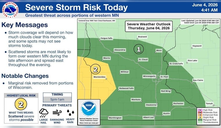
Thursday, June 4 is shaping up mostly cloudy with a high near 82°F and a good shot at scattered to numerous showers and thunderstorms late this afternoon into the evening. The National Weather Service Twin Cities pegs the chance of rain at around 50 percent, with most locations expected to see about a tenth to a quarter of an inch and locally higher amounts where stronger storms pop. South-southwest winds around 10 mph could pick up near any more intense cells. Large hail and damaging wind gusts are a conditional threat but are more favored to the west of the core metro. NWS Twin Cities
Overnight Rain And Local Impacts
Overnight radar estimates and forecast discussions showed heavier totals across western Minnesota, with roughly 2 to 3 inches reported in parts of Yellow Medicine County and about 0.5 to 1.5 inches across much of the broader western region. That early soaking kept low-level moisture loaded up heading into today. In Minneapolis, the main line weakened before it reached the heart of the metro, so the morning impact has been limited to light rain and wet pavement. Still, any isolated heavier shower could briefly cut visibility and cause ponding in low-lying spots. Drivers should be ready for changing conditions this afternoon as new storms may redevelop along leftover boundaries and outflow from earlier cells.
Weekend Outlook And Next Week
After a lingering chance of storms on Friday, the pattern shifts to drier and noticeably warmer weather by Saturday, when highs should climb near 87°F under mostly sunny skies. Sunday looks even hotter, with temperatures pushing toward 89°F and only a slight chance of a late-day shower. Longer-range guidance suggests low-to-mid 90s by the middle to latter part of next week, a warm and humid stretch that forecasters say is worth keeping an eye on. For more on how this setup has been building, see our earlier storm timeline.
How To Prepare
Give yourself extra time for the late-afternoon and evening commute, and keep weather alerts turned on in case any watches or warnings are issued. If you have outdoor plans tonight, line up an indoor backup and secure any lightweight patio furniture or decorations that could get tossed around by gusts. Avoid driving through standing water, and be ready to slow down quickly if a sudden heavy shower moves over your route.


