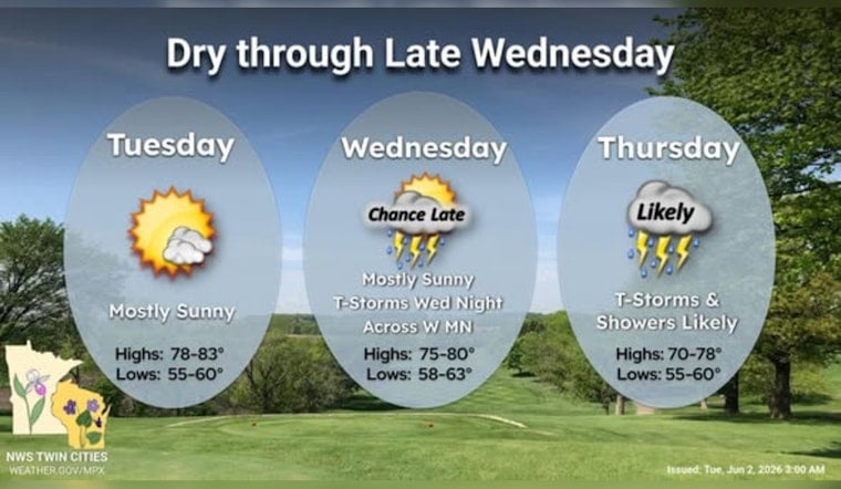
Minneapolis gets the good stuff first. Tuesday, June 2, opens with clear skies, a mild feel, and afternoon highs climbing into the low 80s. It is a classic early-summer day worth sneaking outside for at lunch - because it is also the calm before a much wetter stretch later in the week.
Midweek Soaker And Storms
From late Wednesday into Thursday, a soggy system is expected to roll across the Twin Cities, bringing rounds of showers and thunderstorms. Storms are likely to fire after 7 p.m. on Wednesday, June 3, with the main push and heaviest rain focused late Wednesday night into Thursday, June 4.
Forecasters are calling for high odds of rain in many spots, around 80 percent, with widespread totals near an inch through late week and some isolated heavier pockets possible. The National Weather Service has also outlined a marginal risk of severe storms for Wednesday evening and for Thursday afternoon into the evening, so a few stronger cells cannot be ruled out.
Timing And Impacts
Expect the first storms to develop after 7 p.m. Wednesday, with the late-night and early Thursday stretch bringing the steadiest rain and embedded thunderstorms. South winds will pick up, especially on Thursday, with speeds around 10 to 15 mph and higher gusts in stronger storms. Roads may turn slick, and outdoor events could be delayed or pushed indoors.
If you are commuting Wednesday night or Thursday, it is worth building in some extra travel time. Anyone with outdoor plans should keep an eye on the sky and plan to secure vulnerable items like patio furniture and lightweight decor before the windier periods arrive.
Today And Short-Term Outlook
Tuesday stays mostly sunny with a high near 83°F and light southeast winds around 0 to 10 mph that may turn a bit breezier in the afternoon in some neighborhoods. Overnight into Wednesday looks quieter, with lows in the upper 50s, before the wetter pattern settles in later in the week.
How We're Updating You
We first highlighted this setup in our June 1 post, and the latest forecast sharpens the timing for the heaviest rain while underscoring the marginal severe risk. That is why we are circling back with a more detailed update. For background on how this system was shaping up, see Morning Soaker, Midweek Soaker.
What To Do
Plan on swapping sunscreen for umbrellas Wednesday night and Thursday. Bring rain gear if you have evening plans, secure loose patio furniture and yard items ahead of the gustier periods, and stay plugged into local alerts.
For any watches or warnings that may be issued, follow the National Weather Service and make sure you are signed up for local emergency notifications so you get updates as conditions change.


