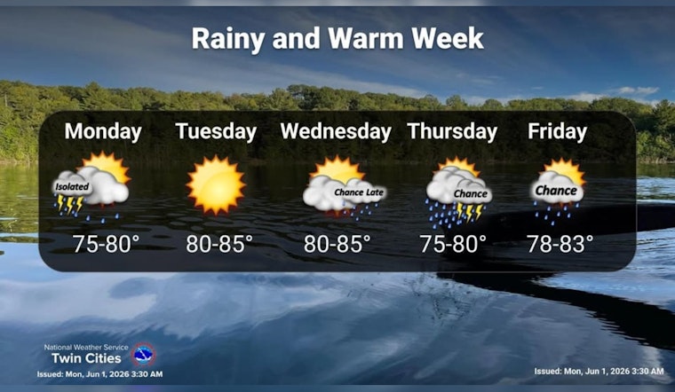
Minneapolis woke up to light rain and a mild 63°F early Monday, with showers sliding across the city to kick off the workweek. The damp start should not last all day, though. Forecasters expect the rain to thin out by late morning, giving way to partly sunny, warm conditions and a high near 80°F. After that, most of the area is looking at a generally dry stretch through Tuesday night before things turn wetter again by midweek.
What To Expect Midweek
The quiet weather will not last. A slow-moving frontal boundary is set to move in late Wednesday into Thursday, bringing a more widespread round of showers and thunderstorms across the Twin Cities. Many spots could see roughly 0.25 to 0.75 inches of rain, with western Minnesota favored for the higher totals. Brief heavy downpours and rumbles of thunder are on the table.
Temperatures are expected to stay above normal into mid-June, with readings climbing into the upper 80s and near 90°F by early next week, according to the National Weather Service Twin Cities.
Temperatures And Wind
High temperatures through Saturday should generally land in the upper 70s to mid 80s. Southeasterly winds are expected around 5 to 15 mph, enough to keep a bit of breeze in the air without causing major issues. Winds may kick up and turn gustier around stronger storms in the midweek window, though forecasters say widespread damaging gusts are not the main concern at this point.
Morning Commute And Outdoor Plans
For the Monday morning commute, showers are expected to taper by late morning, so most drivers will be dealing with light rain or just damp roads rather than a full-on deluge. That said, any stronger shower cells could briefly knock down visibility with heavier bursts of rain.
If you have evening plans, it is still smart to keep an umbrella handy and check the latest updates from the National Weather Service Twin Cities in case any lingering showers or storms pop up.
Where This Leaves You
We flagged this setup yesterday, and the latest forecast largely sticks to that script. The midweek storm timing remains intact, but the window for the heaviest rain is now more tightly focused on late Wednesday into Thursday.
For a refresher on how this pattern has been shaping up, check out our earlier coverage on Minneapolis being on storm watch this week.


