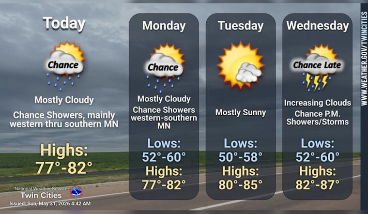
As of 5:30 a.m. CDT Sunday, May 31, 2026, Minneapolis skies were cloudy and about 61°F at Minneapolis–Saint Paul International Airport, with light southeast winds. Sunday is on track to be warm with a high near 79°F and only a slight chance of afternoon showers, while the chance for showers and isolated thunderstorms ramps up late Sunday night into Monday. A light layer should cover the cool early hours and an umbrella is a smart add-on if you will be out after sundown.
Today's forecast
Partly sunny skies are expected this afternoon with southeast winds of 5 to 10 mph and a high near 79°F. There is a slight chance of rain showers before 1 p.m., followed by a slight chance of showers and thunderstorms later that could clip outdoor events. Most precipitation should stay on the lighter side if it develops, according to the NWS Twin Cities.
Evening and Monday
Showers and thunderstorms become more likely late Sunday night, with overnight lows near 61°F and brief jumps into the mid-60s possible before dawn. Monday stays warm, with highs near 79°F and scattered showers and thunderstorms possible through the day. Forecasters note that one or two stronger storms could try to move in from the Central Plains, although metro-wide severe weather is not the primary expectation. It is worth keeping an eye on later updates if you have evening travel or outdoor plans.
Midweek outlook
Tuesday and Wednesday should trend sunnier and warmer, with highs climbing into the mid-80s before a wetter pattern returns Thursday and Friday. Showers and thunderstorms are most likely Thursday, with many areas forecast to receive about 0.25–0.75 inches of rain and a few locations possibly approaching an inch, per the NWS Twin Cities.
Commute and outdoors
Southeast winds of 5 to 10 mph will keep afternoons on the breezy side but generally manageable, and aviation impacts are expected to be minor, although brief downpours can reduce visibility near stronger storms. Metro Transit has Blue Line replacement buses running between Target Field and Fort Snelling on May 30–31, so build in extra time if you are using that corridor and check service alerts before you travel at Metro Transit.
Quick tips
Plan on sunscreen for the warm afternoons and an umbrella for evening activities, and check updates along with local alerts before heading out. For more on how the pattern fits into the broader weekend story, see the balmy weekend preview.


