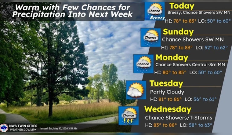
Clouds are hanging over Minneapolis this morning, but the air is mild, with temperatures around 68°F at Minneapolis–Saint Paul International Airport early Saturday, May 30. Expect a mostly cloudy day with a high near 83°F as east-southeast winds ramp up through the afternoon. Tonight trends cooler, with lows slipping into the upper 50s.
Afternoon Winds Pick Up
East-southeast winds should start out around 5–10 mph in the morning and build to 10–15 mph by midday, with gusts in the 20–30 mph range possible late afternoon, especially over open water and near bridges. That breezy stretch could be enough to knock over lightweight patio furniture and make cycling or outdoor dining a bit less fun for short periods. Forecasters lay out the expected wind increase in the office forecast discussion from the National Weather Service.
Sunday Through Next Week
Sunday, May 31 will be partly sunny with a slight chance of rain showers after 1 p.m. and a high near 82°F. Showers and thunderstorms become more likely Monday into midweek, with the better chance for more widespread storms Wednesday into Thursday as a disturbance moves through and highs climb into the mid-80s. For the latest timing and probability of storms, check the forecast from the National Weather Service.
What This Means For You
No watches or warnings are in effect this morning, but it is worth checking updated forecasts before locking in outdoor plans Sunday afternoon or later in the week. A light layer will come in handy for cooler evenings, with lows near 59°F, and it is a good idea to secure loose outdoor items ahead of the gusty late-day winds.


