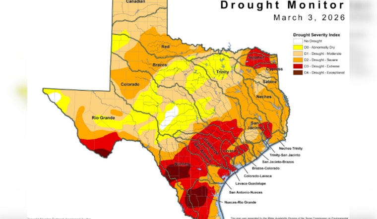
The latest U.S. Drought Monitor map shows drought expanding sharply across the state, marking the fourth straight week of expansion and the largest one-week increase since November 2025. The spread now reaches into the Hill Country and runs from central counties toward the Panhandle and far South Texas, renewing concern about water supplies, rangelands and wildfire risk for communities statewide, as reported by the Texas Commission on Environmental Quality X account.
What the maps show
State environmental officials highlighted the jump in a post on X, warning that the "latest map shows a large expansion of drought from last week" and pointing Texans to state drought resources. According to Texas Commission on Environmental Quality, this is the fourth consecutive week that drought has expanded across the state and the largest one-week expansion since November 2025. The U.S. Drought Monitor's weekly map, using data valid March 3, shows much of central and eastern Texas slipping into moderate-to-extreme drought, with isolated pockets of exceptional drought hanging on in the far south.
Statewide impacts and risks
Regional briefings and federal summaries indicate the situation is already reshaping water and fire planning. As per Drought.gov, soil moisture is well below average across large swaths of the state and combined capacity at Lake Corpus Christi and Choke Canyon was cited near 9.3 percent. The same update pointed to dozens of active wildfires and widespread county burn bans that have pushed short-term fire danger higher.
Farms and ranches feel the strain
On the ground, ranchers and growers report mounting costs as pastures thin and producers buy supplemental feed and haul water into vulnerable herds. Texas A&M AgriLife's crop and livestock reports described ongoing stress to vegetables, specialty crops and grazing lands and warned that hay supplies are tightening in many districts, according to Texas A&M AgriLife. Short bursts of rain have helped in some locations, but extension specialists say those showers have not yet replenished deeper soil moisture.
Where to find maps and guidance
The state maintains a drought resource page that pulls together maps, basin-by-basin information and guidance for public water systems. For the latest state-hosted map and resources, see Texas Commission on Environmental Quality. For context on how conditions shifted this winter, see our earlier coverage of a brief easing in early February.
Outlook
Forecasts show a window for much-needed rain in early March, although climate outlooks do not yet suggest a sustained recovery for all basins. The U.S. Drought Monitor's outlook calls for heavier precipitation in parts of eastern Texas this week, which could bring short-term relief, while western and far-southern basins remain at higher long-term risk, according to U.S. Drought Monitor. Water managers say they will be watching reservoir inflows and soil-moisture indices closely in the coming weeks to see whether this latest expansion backs off or digs in.


