Saturday morning in Minneapolis is starting clear and cool, with temperatures in the low 20s at Minneapolis–Saint Paul International Airport (KMSP). South-southwest winds are light for now but are expected to pick up through the morning as the day warms quickly. Highs are forecast to reach the upper 50s this afternoon, a sharp jump for late March that is helping fuel concerns about late-afternoon fire weather.
Red Flag Warning This Afternoon
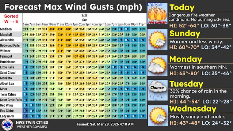
The National Weather Service has issued a Red Flag Warning for much of the Twin Cities metro from noon to 7 p.m. Saturday, March 28, because of warm temperatures, very low humidity, and gusty southwest winds. According to NWS Twin Cities, south-southwest winds could gust as high as 35 mph across the metro, with even stronger gusts farther west. Officials warn that any outdoor burns or sparks could spread rapidly in the dry fuels.
Afternoon Winds Pick Up
Southwest winds of 5 to 20 mph are expected this afternoon, with gusts up to around 35 mph at times, especially from midday into the early evening hours. Gusts could be higher out on Buffalo Ridge and in rural southwest Minnesota, but even in the city, these winds can shove unsecured patio furniture around and make driving higher-profile vehicles more challenging. It is a good day to secure loose items, tie down dumpsters, and take extra care if you are heading to outdoor events this afternoon.
Fire Risk And What To Do
The Minnesota DNR recommends avoiding open burning when conditions are this dry and windy, and advises checking the current burning restrictions map before lighting anything. See the Minnesota DNR's guidance at Minnesota DNR for county-level restrictions and permit information. If you spot smoke or a fire, report it immediately to 911 and keep a safe distance, and do not attempt to fight gust-driven flames on your own.
Rest Of The Week
Dry, warm weather continues into Sunday and Monday, with highs near 68 on Sunday and into the low 70s on Monday, before a more seasonable cooldown arrives midweek. There is a slight chance of isolated rain showers on Monday afternoon and again on Tuesday as the pattern becomes more unsettled, but no major system is expected. Check forecasts early next week for any shifts in timing or new warnings.


