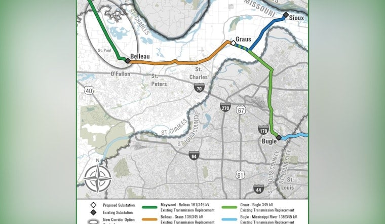
Ameren Transmission is floating plans for roughly 35 miles of high-power transmission lines across northern St. Charles County and wants the public to weigh in before anything is locked in. The proposal would swap out aging wood H-frame and lattice towers for new structures and could shift as much as 19 miles of line onto brand-new corridors. It is part of the Eastern Missouri Grid Transformation Project and includes a new Graus substation near Graus Lake, with an in-service window targeted around 2032.
St. Charles County has posted a summary and map explaining that most of the proposed lines would be rebuilt along existing corridors. A new segment on the west side of Highway 79 could run south from Lincoln County to the Belleau substation near Highway 79 and TR Hughes Boulevard. From there, the line would head east to a proposed Graus substation in the vicinity of Graus Lake, then split toward the Sioux substation and cross the Missouri River into St. Louis County, with an online map available for public comments. According to St. Charles County, the final route has not been set and may change as feedback comes in. The county shared the same summary on its government Facebook page earlier St. Charles County Facebook.
Route Segments And New Graus Substation
Ameren divides the St. Charles County portion of the work into four segments, identified as Maywood-Belleau, Belleau-Graus, Graus-Sioux and Graus-Bugle, and its materials show a new 345 kV Graus substation planned near Orchard Farm. The broader Eastern Missouri Grid Transformation is described as more than 130 miles of new or upgraded transmission lines across six counties, with the goal of boosting system reliability to keep up with future growth. These details appear in Ameren materials that outline study areas and potential corridors.
What The New Towers Will Look Like
The county summary explains that much of the project would replace the older wood H-frame and lattice towers with steel single-pole monopoles. Those are designed to take up less ground space and allow longer spans between structures, which means the towers will look noticeably different along the rebuilt corridors. Local landowners can expect a changed visual profile as routes are finalized and the older towers are swapped out. Maps and graphics showing what that could look like are included in materials from St. Charles County.
Public Input And Timeline
Ameren has already held an initial round of in-person open houses in early March and set up a self-guided virtual engagement site with a comment map so residents can react to the study corridors. The company says this feedback will shape its preferred and alternate routes. Project staff list a dedicated hotline and email address for questions, and they expect to file a final route with the Missouri Public Service Commission later this year while still aiming for in-service dates near 2032. For specific open-house dates and links to the virtual comment tools, see Ameren.
Regulatory Review And What To Expect
Once Ameren submits its chosen route, the Missouri Public Service Commission will review the filing. After a docket opens, the commission accepts written and electronic comments and may set up local public hearings. The agency also publishes step-by-step guidance on tracking cases and submitting filings through its EFIS docketing system. For those instructions, see the guidance from the Missouri PSC.
How To Weigh In
Residents who want a say in where the towers go are being urged to review route options in the project’s interactive map and submit comments through Ameren’s online tool, or to contact the project team directly at [email protected] or by calling 877-468-1823. For formal comments once the case is open at the Missouri PSC, commenters will need to follow the commission’s e-filing directions and include the specific docket number so their remarks are part of the official record. Officials note that routing details could shift as survey work, environmental reviews and consultations with other agencies continue over the coming months.


