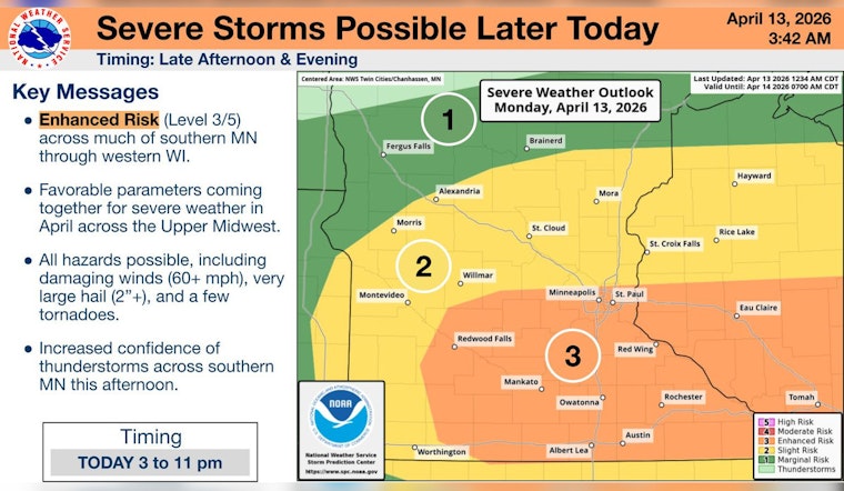
Minneapolis woke up clear and comfy in the mid 50s, but the quiet will not last. A sharp warm-up will push highs into the low to mid 70s before storms roll in this afternoon. Scattered thunderstorms are expected to fire after about 4 p.m., expanding in coverage into the evening. The big concerns for neighborhoods across the city are large hail, strong wind gusts, and brief, heavy downpours that could snarl the evening commute.
Afternoon Storm Threat
Storms should develop along a stalled frontal boundary and may start out isolated before organizing into clusters later. If they stay more separated, they could intensify quickly and reach severe levels, producing large hail and damaging winds. Anyone with outdoor events, kids’ sports or yard work on the schedule should wrap up early or have an indoor backup ready to go.
What The Forecast Office Says
Forecasters at the NWS Twin Cities highlight an elevated (level 3 of 5) severe risk and note that storms that stay discrete could produce "very large hail (potentially to tennis-ball or baseball size), damaging winds and a couple tornadoes." The office says the greatest window for higher end severe weather is the two to three hours after storms first develop, which could line up uncomfortably well with the evening rush.
Timing And Commute Impacts
Storms are expected to initiate after about 4 p.m., with the highest chance for organized severe weather between roughly 4 p.m. and 8 p.m. Heavy rain will cut visibility and could cause quick, localized ponding on low spots and underpasses, so traffic and transit are likely to run slower than normal. If you are on the road when a storm hits, move to shelter as soon as it is safe, and avoid stopping under bridges because hail and wind can damage vehicles and make travel hazardous.
Through The Rest Of The Week
Tuesday looks calmer with highs in the upper 60s and only a few spotty afternoon showers, while Wednesday brings another chance for scattered rain. A stronger front returns Friday with another round of storms and gusts that could reach 30 mph, followed by colder air and the chance of a rain snow mix for parts of the region by Saturday. Keep weather alerts turned on and be ready to adjust outdoor plans quickly through the week.
For more background, see our earlier forecast on the mid-April heat and gusty winds. We will post updates if watches or warnings are issued, and local officials may activate alerts during the afternoon and evening.


