Drivers zipping along North Spring Street and Alameda Street between Union Station and Wilhardt Street are about to get some company in the form of concrete and bollards. The Los Angeles Department of Transportation is reconfiguring roughly 1.2 miles of roadway in Chinatown to add protected bike lanes, new crossing treatments, and upgraded transit boarding areas, with a particular eye on making it easier and safer to reach Los Angeles State Historic Park.
City planners say the project is meant to close a stubborn gap in the bike network and cut down on collisions that have piled up along the corridor.
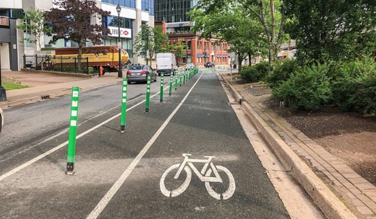
What the plan includes
According to LADOT Livable Streets, the design would remove one vehicle travel lane in each direction to install Class IV protected bike lanes separated from traffic. The plan also calls for protected left turn signals, ADA compliant curb ramps, and a bus boarding island at the intersection of Alameda Street and College Street.
On top of that, the proposal adds pedestrian hybrid beacons at North Spring Street intersections with Mesnager Street and Ann Street, as detailed by the Bicycle Advisory Committee.
Safety case
Project documents note that the corridor saw 46 traffic collisions between 2013 and 2022, including six fatal or severe injuries involving people walking or biking, which leaders point to as a key reason for stepping in.
As materials for LADOT Livable Streets make clear, long uninterrupted blocks and high speeds have turned crossings into a risky maneuver for park visitors and transit riders who have to cross multiple lanes of fast-moving traffic to reach bus stops and trail entrances.
Why Chinatown and the park
The Spring and Alameda corridor frames the eastern edge of Los Angeles State Historic Park and sits within walking distance of the A Line Chinatown station. Advisory documents point out that there are no signalized crossings for more than a half mile between Wilhardt Street and College Street, which leaves a long stretch where people on foot are left to fend for themselves.
The Bicycle Advisory Committee notes that the corridor ranks highly in LADOT’s internal prioritization for closing bike network gaps, improving first and last mile access to transit, and addressing high injury locations on the city’s bike network.
Timeline and outreach
LADOT says the Spring and Alameda project is currently in the outreach and engagement phase. That work includes an online survey and community pop-ups that are shaping the design and collecting feedback from people who use the corridor in different ways.
Subject to final design and permitting, the department has signaled it hopes to move from outreach into construction in 2026. Officials say design updates will be posted on the LADOT Livable Streets project page as the plans evolve.
Part of a bigger push
The Spring and Alameda effort is one piece of a broader build-out of protected bike infrastructure across Los Angeles. LADOT is advancing plans for protected facilities on Martin Luther King Jr. Boulevard and for a multi-mile protected corridor on Pico Boulevard, signaling that the city is leaning into separated bike lanes rather than paint only projects.
Urbanize LA has reported that similar tradeoffs, such as lane reductions, new crossings, and transit access improvements, are central to the city’s approach on the MLK and Pico corridors as well.
What to expect
On the ground, the design choices are expected to mean narrower vehicle lanes in some spots, new curb treatments where space allows, and concrete or physical separation for people on bikes. LADOT staff say the goal is to balance safety gains for people walking and biking with the needs of transit operations and local access for residents and businesses along the route.
The corridor was identified as a priority in the city’s Mobility Plan 2035, and officials say final designs and construction timing will be announced through the city’s usual public notice channels once design work wraps up.


