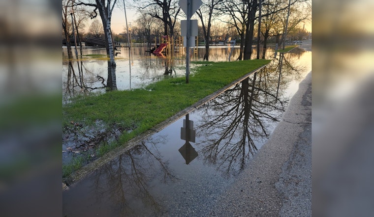
With heavy runoff already pushing levels up and more rain in the forecast, Burlington officials spent Friday keeping a close eye on the Fox River and warning residents that rising water could soon shut down streets and parks.
The National Weather Service is projecting that the river near Burlington could crest around 12.5 feet by Friday evening, a level high enough to trigger flood preparations across the city. In response, city and county crews are staging flood resources and gearing up for what could be a messy evening commute.
Racine County Emergency Management and the City of Burlington say sand and sandbags will be available to residents later Friday afternoon. The pickup site is set for the 600 block of Maryland Avenue, with distribution starting after 2 p.m. Residents in low-lying spots may want to clear a little trunk space.
In a news release cited by FOX6 Milwaukee, the city urged property owners to monitor both the Fox and White Rivers and to size up their individual flood risks. The release warns that flooding at the currently forecast level “will likely trigger street and park closures” and suggests planning for short-term access headaches around the riverfront.
Racine County Emergency Management is coordinating with Burlington to staff the Maryland Avenue staging area and get sand and sandbags into residents’ hands. Officials are also reminding people with flood-prone basements to move valuables to higher levels and to get pumps and barriers ready if they have them.
What the National Weather Service Is Saying
The National Weather Service office in Milwaukee/Sullivan is calling for rising river stages across southeast Wisconsin, and the Fox River near Burlington is on the list of gauges expected to reach flood stage. Their river forecasts and hydrographs show how quickly levels can swing when additional rain falls, so they are updating products as new model runs come in.
Local authorities are citing an National Weather Service projection that puts the crest near 12.5 feet on Friday evening. At that height, low-lying riverfront and park areas can see water creeping in, even if homes stay dry. Residents are encouraged to follow the latest official river forecasts and statements to see whether conditions are improving or getting worse.
Tracking River Levels in Real Time
For anyone who prefers numbers straight from the source, live streamgage readings from the U.S. Geological Survey offer a second, independent way to track the Fox River between forecast updates. The USGS station for the Fox River near Burlington posts current stage and short-term trends that emergency managers and first responders watch closely.
Local officials recommend checking the gauge before driving through low-lying routes or returning to properties that might already be taking on water. Real-time measurements from the Fox River site are available on the USGS page for the Burlington station.
Where to Pick Up Sand and Sandbags
Racine County Emergency Management and Burlington crews plan to make sand and sandbags available to the public after 2 p.m. at the 600 block of Maryland Avenue, according to the city’s release reported by FOX6 Milwaukee. It is a self-help setup, so residents should bring shovels and a way to haul filled bags.
On-site staff are expected to guide people on where and how to fill bags and how many are appropriate to take. Officials are emphasizing that sandbags are a short-term tool, not a permanent fix, and that proper placement is key if residents want to keep water out of basements and first-floor doorways. City channels will carry any updates on hours or additional staging sites if conditions change.
How to Prepare and Stay Safe
Authorities are repeating the familiar flood-safety rules: never drive into flooded roads and avoid walking through flowing water, since even shallow water can be dangerous, according to the National Weather Service. Generators and pumps should be kept away from standing water and downed power lines, and valuables should be moved to higher floors where it is safe to do so.
Residents are encouraged to monitor city alerts, review National Weather Service flood-safety guidance and keep an eye on the USGS gauge for the latest conditions. Officials say to call 911 if anyone is in immediate danger, and note that any road closures or changes to sandbag distribution will be posted on official city and county channels as the situation develops.


