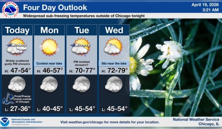
Chicago woke up to a brisk, mostly clear Sunday morning on April 19, with neighborhoods away from the lake sitting in the upper 30s (about 37°F) and a west-southwest breeze cutting through the quiet streets. Today stays on the cool side, with highs near 49°F, while winds ramp up through the afternoon and a few spotty rain showers try to muscle in. Many suburban neighborhoods should expect patchy frost this morning, with a Freeze Warning in effect from 12:00 a.m. to 9:00 a.m. Monday, April 20, 2026, for areas outside central Cook County. After that early-season chill, a sharp warm-up follows, and Tuesday is on track to feel much milder, with highs near the low 70s.
Afternoon Gusts and Spotty Showers
Mostly sunny skies this morning are expected to give way to a chance of showers after noon, especially across the northern and northwest parts of the metro area. Forecasts put the odds at roughly a 30 to 40 percent chance of brief showers. West winds of 10 to 15 mph will strengthen and turn gusty this afternoon, with gusts up to about 30 to 35 mph possible near the lake and over exposed bridges. According to the National Weather Service Chicago, any heavier showers should be short-lived but could still pack brief heavier downpours or stronger gusts.
Overnight Frost And Freeze Risk
Clear skies and lighter winds tonight will let temperatures tumble, especially away from Lake Michigan, with lows in the upper 20s to lower 30s for many suburbs. Forecasters warn that frost, and a brief freeze in sheltered spots, could damage tender plants and unprotected outdoor plumbing in much of the outlying area overnight into Monday morning. If you have potted or vulnerable plants, bring them indoors or cover them, and consider shutting off or draining exterior irrigation and garden hoses before the cold settles in.
Boaters, Commuters And The Week Ahead
Boaters should use caution, as nearshore waters are expected to turn choppy with gusty winds, and small craft operators in particular should rethink any solo or lightly equipped outings today. The pattern flips quickly to milder after Monday, with highs near 72°F on Tuesday and mid-to-upper 70s, even low 80s inland, by Thursday. That warm stretch arrives ahead of another system that could bring showers and thunderstorms late Thursday into Friday. Keep an eye on evening forecasts if you have outdoor plans later this week, and move sensitive plants to protected spots for the next two mornings before spring finally starts acting like it.


