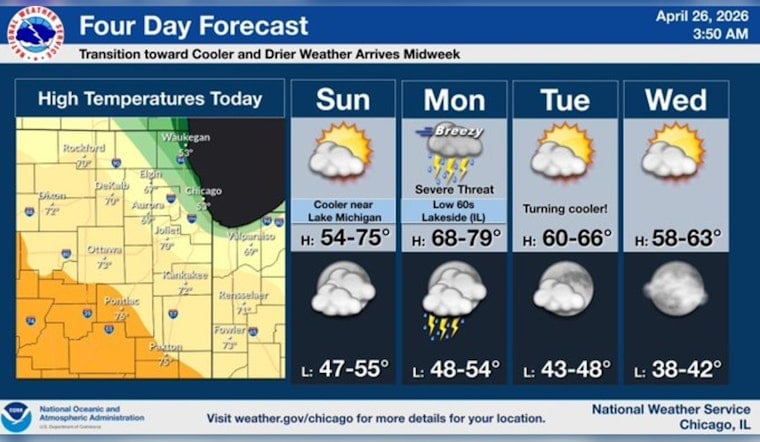
Chicago is waking up to a gray, clammy start this Sunday, April 26, 2026, with patchy fog and mist clinging to the lakefront and temps hovering in the mid‑40s (around 46°F). Visibility is running at about five miles near the water. The good news: skies should brighten by midmorning into a partly sunny afternoon with highs near 55°F. The catch: all of this is just the pregame for a much stronger storm system expected to roll in on Monday.
Fog This Morning, Brighter Afternoon
Fog will hang around the hardest through late morning, especially along the Lake Michigan shoreline and in north‑shore neighborhoods, then gradually thin out. East‑northeast winds around 5–10 mph are expected this afternoon, with gusts up to 20 mph and cooler readings within a few blocks of the lake.
If you are driving, biking or running errands along the shore, plan on slower going while visibility is reduced and give yourself extra time.
Severe Storms Monday, April 27, 2026
On Monday, April 27, showers and thunderstorms are likely to fire up after about 7 a.m. Some of those storms could turn severe, bringing large hail, damaging straight‑line winds and isolated tornadoes. Heavy downpours may trigger localized flooding, with new rainfall totals of roughly a quarter to a half inch possible and higher amounts where the strongest storms park overhead.
Forecasters at NWS Chicago are urging residents to keep a close eye on watches and warnings, noting that the exact timing and placement of the roughest weather could still shift.
Commute And Travel Impacts
This morning’s fog could slow lakeshore commutes and obscure bike paths, and Monday’s storms may knock out power, bring down branches and tangle air and rail travel during the afternoon and evening rush.
We flagged the growing threat yesterday in our earlier piece on twisters, torrents and trouble, including concerns about rivers and quick rises in water. Intense rain in a short burst can overwhelm storm drains and lead to fast‑developing urban flooding.
How To Prepare
There is still time to get ready. Secure outdoor furniture and trash cans, charge phones, and keep a basic emergency kit where you can grab it quickly. If you normally park on low‑lying streets or next to drains that back up, move your vehicle to higher ground.
When storms arrive, if you hear thunder or see frequent lightning, head indoors right away and stay away from trees and metal objects outside. Keep alerts enabled on your phone, and have a battery‑powered radio or NOAA Weather Radio as a backup in case the power or cell service cuts out.
Check the National Weather Service and local media on Monday for any watches and warnings. We will update if watches or warnings are issued for the Chicago area.


