A magnitude-5.7 earthquake jolted the area near Silver Springs, Nevada, on Monday evening, sending a long roll of shaking across parts of Northern California and into Sacramento. The quake hit shortly after 6:30 p.m. Pacific, and residents from both states reported feeling the ground move. Authorities said there were no immediate reports of major damage or injuries.
USGS Pinpoints Epicenter Near Silver Springs
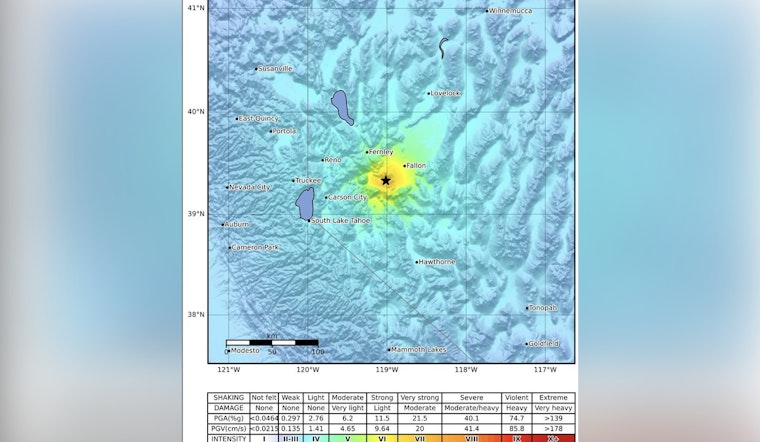
The U.S. Geological Survey recorded the temblor as a magnitude 5.7, with an epicenter roughly southeast of Silver Springs in Lyon County, and a preliminary depth of about 9 kilometers. The agency lists the time at 6:29 p.m. Pacific and provides a shake map showing perceptible movement stretching well into the Sacramento region.
Shaking Reported Across Northern California
Residents described a rolling motion that moved through the valley, and local TV stations noted dozens of calls and social media posts from people who felt the quake. According to ABC10, there were no immediate reports of structural damage or injuries, although officials urged people to give their homes and workplaces a quick safety check for things like gas leaks, toppled furniture, or fallen items.
Why Quakes Here Can Be Widely Felt
Nevada sits within the Basin and Range province, a broad zone of crustal stretching that generates frequent earthquakes across the state, according to the Nevada Bureau of Mines and Geology. Seismologists say relatively shallow quakes in this region can produce long-period waves that travel a long way, which helps explain why people hundreds of miles from the epicenter reported feeling Monday night’s shaking.
How To Report Shaking And Stay Safe
If you felt the quake, the U.S. Geological Survey's “Did You Feel It?” survey lets you share what you experienced and helps scientists map shaking intensity. For official information where you live, local officials recommend following county emergency management pages and trusted broadcasters for any updates or safety instructions.


