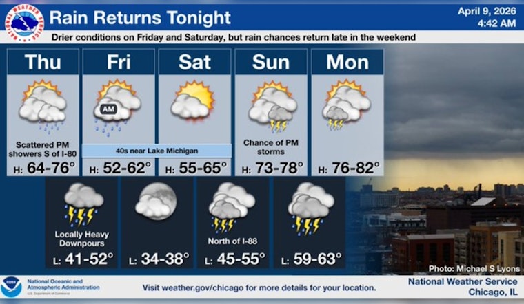
As of 5:35 a.m. CDT Thursday, April 9, 2026, Chicago was mostly cloudy with temperatures hovering around 59°F. Scattered morning showers are expected to taper by mid‑morning, then skies should turn partly sunny as the high climbs to roughly 68°F. South winds at 10 to 15 mph with gusts up to 25 mph will keep the city feeling breezy to start the day.
Afternoon Lull, Nighttime Soaker
The afternoon looks largely dry and partly sunny, a decent window for errands or a quick lakefront walk before the weather turns cranky again. A wetter round of showers and thunderstorms is on track to return late Thursday evening and continue overnight.
The latest forecast discussion from the National Weather Service warns that many areas could pick up one-half to three-quarters of an inch of rain, with isolated totals exceeding 1 inch north of the Illinois and Kankakee River valleys. That amount of water could trigger new rises on rivers and creeks in those areas. North‑northeast winds should ease to about 5 to 10 mph as the heavier rain moves through.
Tonight's Commute And Conditions On The Water
The evening commute into the overnight hours may slow to a crawl where heavier downpours set up, with brief flooding and sharply reduced visibility possible under stronger storms. If you have to drive, build in extra travel time and steer clear of standing water. As the saying goes, "turn around, don’t drown."
Boaters and shoreline runners should keep a close eye on conditions and hold off on nonessential outings until winds and waves calm down. A late workout is not worth tangling with choppy water and sudden downpours.
Weekend Outlook
Friday turns noticeably cooler, with highs near 48°F and showers tapering through the morning before giving way to a mostly clear evening. Saturday looks calmer and mostly sunny with highs close to 50°F, setting up a quieter start to the weekend.
By Sunday and into early next week, a broader warm pattern returns, with highs climbing into the 70s and renewed chances for thunderstorms. You can track updates and any timing tweaks at the National Weather Service Chicago.
If you have evening plans, keep an umbrella within reach and make sure weather alerts are enabled on your phone. If flooding develops in your area, follow local guidance and avoid travel unless it is truly necessary.


