Most of Wisconsin spent Friday under a tornado watch as a fast-moving cluster of severe storms pushed into the Upper Midwest, with forecasters warning of large hail, damaging winds and an isolated tornado threat. The watch runs until 8 p.m. CDT on April 17 and covers dozens of counties across southern and central parts of the state. Emergency managers urged residents to review their safety plans, decide now where they will shelter and keep multiple ways to receive warnings. The alert follows earlier rounds of severe weather this week, including a confirmed tornado touchdown near Gilman.
Which Areas Are Covered
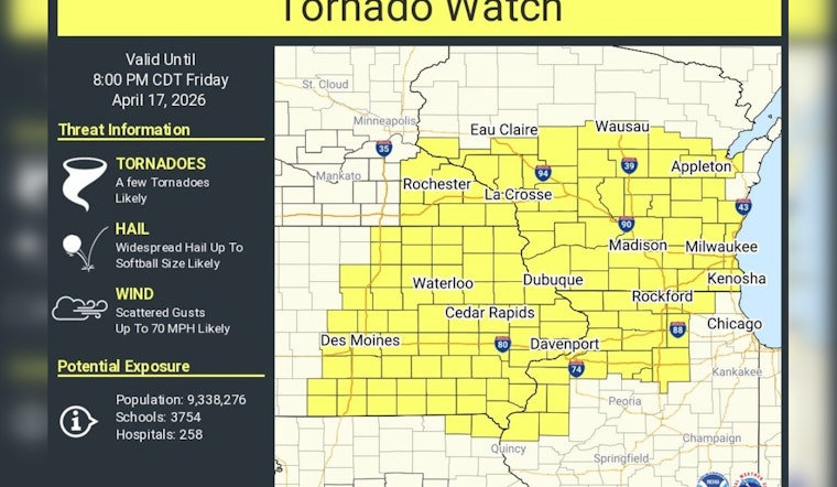
According to the National Weather Service, Tornado Watch 129 is in effect until 8 p.m. CDT for dozens of Wisconsin counties and also includes parts of southeast Minnesota, northeast Iowa and northwest Illinois. The official watch product lists many counties in southern and central Wisconsin, including areas around Milwaukee, Dane and Waukesha.
What Forecasters Are Warning About
As outlined by the Storm Prediction Center, numerous severe thunderstorms are expected and could produce very large hail early, followed by increasingly damaging straight-line winds later this evening. Forecasters warned that severe wind gusts could reach into the 60–90 mph range in some locations and that supercells capable of all hazards, including hail, wind and tornadoes, are possible before storms organize into a line.
Recent Touchdown Near Gilman
The Gilman Rural Fire Department and the National Weather Service confirmed a tornado touched down north of State Highway 64 earlier in the week, causing limited structural damage and no reported injuries, according to WSAW. Meteorologists in the Milwaukee/Sullivan office said storms moving across northeast Iowa were likely to push into southern Wisconsin, a detail highlighted in coverage by the Milwaukee Journal Sentinel.
Watch Versus Warning: What To Do Now
A tornado watch means conditions are favorable for tornadoes; a tornado warning means one has been sighted or is indicated by radar and you should take shelter immediately. The National Weather Service advises people to move to a basement or interior room on the lowest floor, avoid windows, and keep a battery-powered NOAA Weather Radio or mobile alerts handy.
Power Outages And Local Impact
Earlier rounds of storms this week knocked out power to large swaths of southeastern and central Wisconsin, with utilities and crews working overnight to restore service to tens of thousands of customers. Local outlets reported that utilities were responding around the clock as communities in Waukesha and other counties surveyed damage and cleared downed trees and lines, according to FOX6 Milwaukee.
Where To Get Real-Time Updates
State emergency managers and ReadyWisconsin urge residents to sign up for local alerts, monitor NOAA Weather Radio and follow the National Weather Service and local broadcasters for warnings and shelter instructions. If you are in the watch area, identify your safest interior room now and avoid driving into developing storms; local emergency managers and utilities will post updates as conditions change.


