Chicago woke up under a gray lid Tuesday morning, April 28, 2026, with Midway sitting near 54°F and visibility around 10 miles. A brisk west-northwest breeze is already working over the city, and any neighborhood that lucks into some afternoon clearing can sneak into the lower 60s. A light jacket is still a smart move for the morning commute, and it is not a bad idea to secure patio furniture and trash bins since gusty periods are on the table.
Afternoon Winds Pick Up
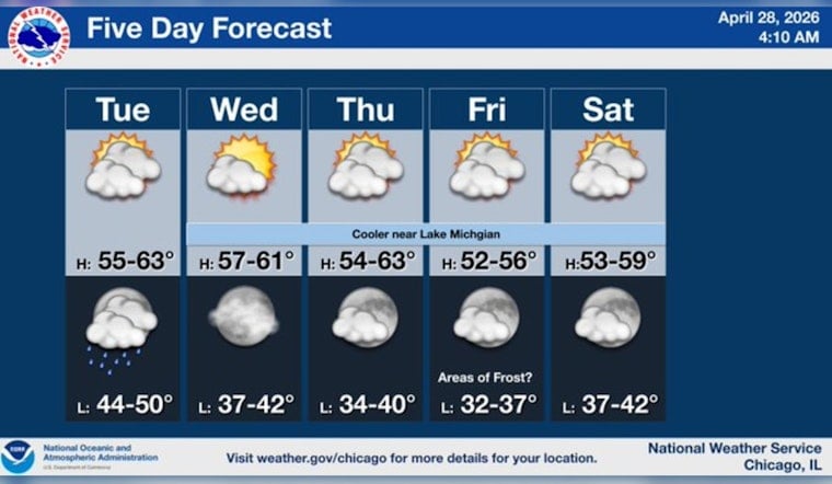
Highs this afternoon are expected to top out near 62 to 63°F, with west-northwest winds of 5 to 15 mph and gusts that could reach 30 mph, most noticeable from late morning into early afternoon. Along the lakefront, onshore flow should keep things a few degrees cooler than spots farther inland, so downtown and immediate shoreline neighborhoods will likely feel more spring chill than warmth. These conditions line up with the latest outlook from the National Weather Service Chicago.
Tonight Into Wednesday
An upper level shortwave is expected to kick up scattered rain showers late Tuesday night, mainly after 10 p.m., and continuing into early Wednesday morning. Rain totals look light, generally under a tenth of an inch for most of the metro area. Temperatures will slip into the mid 40s this evening, then edge up slightly overnight as clouds thicken. Showers should taper by late Wednesday morning, with partial clearing during the afternoon. Early commuters should plan for damp streets, though no major weather related disruptions are anticipated.
Boaters And The Lake
A Small Craft Advisory is in effect for the nearshore waters until 10 AM CDT Tuesday, April 28, with winds up to 30 knots and waves building to several feet. Inexperienced mariners are urged to stay off the lake, according to the NWS advisory. Beachgoers can expect choppy conditions and stronger onshore gusts through the morning, so this is more of a wave watching day than a toe in the water day.
Weekend And Frost Risk
The broader pattern trends cooler and drier as the calendar flips into early May. Friday, May 1 is pegged as the coolest day in the short term forecast, with calm and clear nights that could let temperatures sink into the low to mid 30s. That is cold enough for frost to develop in low lying and outlying neighborhoods. Gardeners and anyone tending tender plants should be ready to cover or bring them in Friday night if you are away from the immediate lakeshore, where temperatures typically stay a bit milder.


