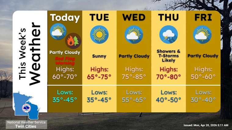
Sunshine over the Twin Cities came with a side of nerves on Monday, as a chilly morning in the 30s headed toward a seasonably warm high near 62°F and a heightened fire risk. The National Weather Service has issued a Red Flag Warning for much of central through southwestern Minnesota from 11 a.m. to 8 p.m. Monday, April 20, 2026, thanks to gusty southerly winds and very low humidity that could quickly spark and spread fires. Locals planning to burn yard debris, fire up the grill, or run heavy outdoor equipment are being urged to hold off on open burning and to secure patio furniture before this afternoon's stronger gusts arrive.
Afternoon Winds And Fire Risk
Southerly winds are expected to ramp up through the morning and turn solidly breezy by midday, with sustained speeds of 10 to 15 mph and gusts that could reach 30 mph across parts of the region. Dewpoints are forecast to linger in the 20s, which will push relative humidity into the low to mid 20 percent range. Forecasters say that combination is close to critical for fire spread and is the reason for the Red Flag Warning, according to NWS Twin Cities.
Where Restrictions Matter Today
The warning zone covers a wide slice of central and southwestern Minnesota rather than just downtown Minneapolis, although gusty winds and any smoke from fires could still affect neighborhoods and the afternoon commute. The Minnesota Department of Natural Resources manages county by county burning restrictions and can temporarily ban recreational or debris burning when fire danger climbs. Residents are urged to review local rules and the statewide burn map before lighting any fires and to reach out to a local fire warden with questions, according to Minnesota DNR.
What Comes Next
Temperatures are expected to stay above normal through midweek, with highs near 72°F on Tuesday, April 21, 2026, and climbing into the low 80s by Wednesday, April 22, 2026. A stronger system sliding through on Thursday, April 23, 2026, should bring a chance of showers and thunderstorms, with forecasters highlighting a better shot at rain later Thursday along with the potential for more gusty winds. Cooler, drier air is projected to return for the weekend, which should ease fire concerns for most areas, according to NWS Twin Cities.
Legal Implications
Burning restrictions are not just friendly advice. They can be enforced by local jurisdictions and the DNR, and people can face fines or even liability for damages if a fire escapes control. Anyone using a permit should double check its status with county officials and the DNR before striking a match to avoid penalties and potential suppression costs.


