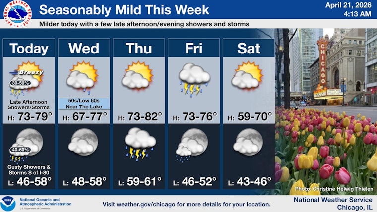
Chicago woke up on the cool side Tuesday, April 21, 2026, with temps hovering around 50°F, but the city is headed for a quick warm-up into the mid-70s this afternoon. The tradeoff: scattered showers and thunderstorms are expected after 3 p.m., and strengthening southwest winds at 15–20 mph with gusts near 30 mph will mean a breezy commute and choppy conditions on Lake Michigan.
Afternoon Storms And Winds
The main action window runs from late afternoon into the evening, with about a 50% chance of showers and thunderstorms after roughly 3 p.m. The overall severe risk is low, but a few strong, gusty storm cores are possible, especially south of I-80 and east of I-55. Those could bring locally damaging wind gusts or small hail. Southwest winds will ramp up to 15–20 mph with gusts near 30 mph, creating rougher waters on Lake Michigan and a higher grass-fire risk where vegetation is dry. The nearshore waters are under Small Craft Advisories into the afternoon, so boaters and anyone with evening outdoor plans should stay plugged into updates, according to NWS Chicago.
Looking Ahead
Wednesday starts with patchy fog near the lake before skies turn mostly sunny inland. Expect highs in the upper 50s right along the shoreline, with warmer readings as you move farther inland. Thursday looks breezy and much warmer, with highs near 78°F, ahead of a more widespread round of showers and thunderstorms that arrives Thursday night into Friday. For more context on the fast frost-to-warm swing and this week’s trend, check out the frosty wake-up that had gardeners scrambling.
What To Do
If you have outdoor plans this afternoon or evening, secure lightweight patio furniture and have an indoor backup ready between roughly 3 p.m. and 9 p.m. Plan on a little extra travel time to handle gusty crosswinds and sudden downpours, and keep your phone charged so you can get weather alerts and quick updates if storms flare up over your neighborhood.


