Minneapolis woke up under low gray clouds and patchy fog Monday, with temperatures parked in the upper 50s. The city should climb to a high near 66°F on May 18, 2026, but the relatively dry stretch will not last. Another round of showers and thunderstorms is expected late Monday evening into the overnight hours, so plan on wet roads and slower travel tonight.
Tonight's Rain And Thunder Threat
A corridor of showers and thunderstorms is expected to push northeast across the region Monday evening, with the heaviest rain and best chance for thunder between about 8 p.m. and midnight Monday night, May 18, 2026. The wettest band could drop roughly three quarters to one inch of rain from far‑southern Minnesota into west‑central Wisconsin, while most other spots should pick up a few tenths of an inch. For detailed timing and impacts, see the National Weather Service Twin Cities.
Morning Fog And The Commute
Patchy fog before mid‑morning may briefly reduce visibility on side streets and river crossings; overnight lows dipped into the mid‑50s and readings are only slowly climbing. Budget a few extra minutes for early trips and use low beams in fog. Transit riders should check Metro Transit Rider Alerts for service updates, since wet, slow conditions can lead to delays.
Airport Outlook
Minneapolis–St. Paul International is likely to see low ceilings through much of the day, with spotty IFR conditions this morning and lingering low clouds into the afternoon. The next round of showers is expected to begin around 6–7 p.m., with the best chance for thunder between about 9 p.m. and midnight. Stronger cells could produce brief gusty winds and localized heavy downpours, so travelers with evening flights should monitor their airline for possible weather-related delays.
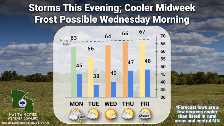
What To Expect Midweek
Behind the system, Tuesday will feel noticeably cooler with a high near 57°F and northwest winds around 15 mph, gusting up to about 30 mph in places. Drier and more seasonable weather returns by Wednesday with highs in the mid‑60s, though late‑week nights could turn chilly if skies clear. This page will be updated if any watches or warnings are issued.
Related Coverage
For background, see our weekend preview on the same pattern, which lays out the larger storm setup; this is an updated forecast with specific timing and rainfall amounts for tonight. Hoodline's earlier piece is available in its weekend storm preview.


