Monday, May 25, 2026, is shaping up to feel like midsummer in Jacksonville, with muggy highs near 89°F and scattered afternoon storms on the schedule. The big trouble spots: a high rip current risk at area beaches through late tonight and inland heat indices climbing into the mid to upper 90s. If your Memorial Day plans involve the sand or any late day cookouts, be ready for gusty winds, brief heavy downpours and a quick dash indoors if storms pop.
Afternoon Storms And Heat
Mostly sunny skies this morning are expected to give way to a chance of showers and thunderstorms after 1 p.m., with the best coverage from late afternoon into the evening. Southeast winds will run about 7 to 13 mph with gusts up to 18 mph. Most spots will see a tenth to a quarter of an inch of rain, but slow moving storms could dump heavier bursts that lead to localized ponding on streets and in low spots.
Isolated strong to marginally severe storms remain possible inland, especially across the Suwannee Valley and parts of inland Southeast Georgia. Any stronger cells could bring frequent lightning and gusty winds, according to the National Weather Service.
At The Beaches
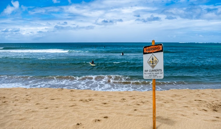
The National Weather Service has a Rip Current Statement in effect for Northeast Florida and Southeast Georgia beaches through late tonight. Onshore southeast winds and 3 to 4 foot surf are creating dangerous currents for swimmers.
Officials urge beachgoers to swim only at lifeguarded beaches, follow posted flags and signs, and avoid fighting the current if you are pulled out. If you are caught in a rip current, float, signal for help and wait for assistance instead of trying to swim straight back to shore.
Local outlets and beach patrols have reported an uptick in rescues over the holiday weekend, so expect extra lifeguard and sheriff patrols at the most popular stretches of shoreline. For local advisories and updates, check News4JAX.
Plan Your Day
For Memorial Day gatherings, the safer bet is to front load outdoor plans into the morning or have a covered backup spot ready. Afternoon storms can fire quickly, bring brief street flooding and gusty winds, and send grills and lawn chairs scrambling.
Heat will be another issue. Inland heat index values are expected to reach the upper 90s through Friday, so it is smart to limit strenuous activity during the hottest hours and keep water, shade and breaks in the mix if you are outside for long stretches. Keep an eye on the forecast, watch beach flags closely and head indoors if thunderheads start building over your neighborhood.
Looking Ahead
The summer style pattern does not go anywhere this week. Tuesday, May 26 is expected to look much the same, with highs near 89°F and scattered afternoon storms. Wednesday, May 27 and Thursday, May 28 bring higher storm chances on top of the hot, humid air already in place.
Longer range guidance keeps daily thunderstorm chances in play into the weekend, and officials note heat index values around 95 to 105°F through Friday. If you have outdoor plans later in the week, it will pay to keep checking for updates and be ready to tweak the timing if storms and heat line up at the wrong time.


