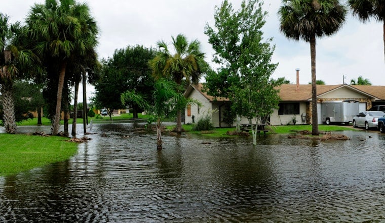
New Orleans rolled into Sunday, May 24, 2026, with sticky pre-dawn air, low-70s temps, and a whole lot of false confidence. The quiet is not expected to last. Forecasters are calling for repeated rounds of showers and thunderstorms through the day, with quick-hitting downpours that could trigger brief urban flooding. A high near 80°F and light southeast winds around 5 mph are on tap, but many neighborhoods are likely to see multiple intense bursts of rain. A Flood Watch is in effect across southeast Louisiana through Monday evening, May 25, 2026, so residents should be ready for soggy travel and shuffled holiday plans.
What To Expect Today
Showers and thunderstorms are likely this morning, with the heaviest activity favored from late morning into the afternoon. Overall rain chances sit near 90 percent, and many spots could pick up roughly three quarters of an inch to one inch of new rainfall, with locally higher totals under stronger storms, according to the National Weather Service New Orleans. Winds should stay light around 5 mph, but intense downpours may slash visibility and slow commutes, especially during peak travel times.
Forecasters are also watching for pockets of training storms, or storms that redevelop over the same area, which raises the flash flood risk for low-lying streets and neighborhoods with poor drainage. A radar echo that seems stuck over your block can turn into curb-to-curb water faster than most drivers expect.
Flood Watch And Travel Impacts
The Flood Watch remains in place through Monday evening and covers southeast Louisiana and southern Mississippi. The watch signals that flash flooding is possible if heavy storms repeatedly cross the same locations. On Memorial Day itself, some areas could see an additional 1 to 2 inches of rain, which means street flooding and ponding are likely in the usual trouble spots.
If you have to get behind the wheel, avoid standing water, give yourself extra time, and fight the urge to test that mystery puddle. The long-standing advice still applies: turn around, don’t drown is the safest move on a flooded road.
Why This Update Matters
This wet setup extends the soggy trend that Hoodline highlighted on Saturday. Repeated bursts of deep tropical moisture will keep the threat going through the holiday, so what starts as a quick shower can ramp up into heavy rain in a hurry. For more background on the pattern and earlier watches, see yesterday's stormy wake up call, and keep an eye on local alerts if you have outdoor events planned for Monday.
Quick Safety Tips
Move vehicles off low-lying streets if your neighborhood floods easily, and avoid driving through standing water, no matter how many trucks in front of you try their luck. Keep your phone charged and make sure you have several ways to receive warnings. If water rises quickly, follow official instructions and head for higher ground. Signing up for NOLA Ready alerts and monitoring the National Weather Service will help you stay ahead of any fast changes in the forecast.


