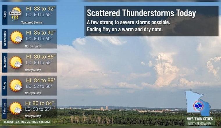
Tuesday, May 26, 2026: It’s already a bright, warm start across Minneapolis, with clear skies and temperatures holding near 72°F at Minneapolis–Saint Paul International Airport. Southerly winds and climbing humidity are teaming up for a hot afternoon that could nudge much of the metro into the low 90s.
Afternoon Heat and a Late Storm Threat
Highs near 90°F are on tap for Tuesday afternoon, with showers and thunderstorms expected to develop after about 4 p.m. Coverage looks to peak in the early to mid-evening hours. The National Weather Service Twin Cities notes that storms should stay scattered. Any stronger cell could still pack a quick punch with brief heavy rain, small hail, and gusty outflow winds, but a widespread severe weather event is not anticipated.
Timing and Commute Impacts
If you have outdoor plans, late afternoon into early evening is the stretch to watch. Storms may bubble up quickly and cause short-lived, localized delays on major roads or at MSP. Most spots are expected to see light rainfall totals, generally under a tenth of an inch, yet a passing downpour, burst of wind, or small hail could toss around lawn furniture and slow traffic wherever a cell moves through.
Rest of the Week
Wednesday delivers a slight cooldown, with highs backing off into the upper 80s and only isolated chances for storms. After that, high pressure noses in late week and into the weekend, keeping conditions mainly dry. Daytime highs should settle into the low to mid-80s through early next week.
Beat the Heat
If the warmth feels a bit much, Hennepin County maintains an interactive list of cooling options, including libraries, pools, and community centers, where residents can find air-conditioned space. Basic heat smarts still go a long way: drink plenty of water, take it easy during the hottest part of the afternoon, and keep a weather app handy if you plan to be outside later today.


