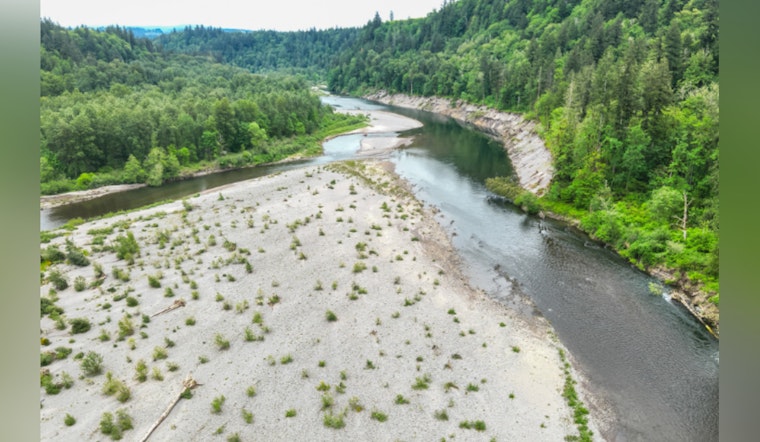
The Sandy River’s go-to float stretch just got a lot less friendly. River officials are urging people to steer clear of the popular corridor between Oxbow Regional Park and Dabney State Recreation Area after winter storms shifted the channel and left behind hidden hazards. The Multnomah County Sheriff’s Office River Patrol says fallen and submerged trees in the new flow can trap boats and swimmers, so as boating and swimming season ramps up, crews want locals taking this section very seriously.
Our River Patrol Unit is issuing a safety advisory for community members utilizing the Sandy River between Oxbow Regional Park and Dabney State Recreation Area. Following a powerful storm cycle in December 2025, the river’s path has naturally shifted, creating new and potentially significant hazards for recreational users. The change in the river's course introduced strainers into the new primary channel; the current is pulling watercrafts and swimmers toward these obstructions.
— Multnomah Co. Sheriff's Office (@multcoso) May 7, 2026
What the sheriff's office warned
As posted by the Multnomah County Sheriff's Office, the River Patrol Unit reported that a powerful December 2025 storm shifted the Sandy River’s primary channel and funneled fallen and submerged trees into that new flow. Deputies warn the current can pull watercraft and swimmers straight toward those obstructions, increasing the risk of entrapment and capsizing. The advisory specifically highlights the corridor between Oxbow Regional Park and Dabney State Recreation Area as the main trouble zone.
Why strainers are deadly
Strainers, which include logjams, overhanging branches and submerged trees, let water pass while trapping solid objects. They are especially dangerous in fast current, where getting yourself free is extremely difficult. The Oregon State Marine Board notes that strainers can pin paddlers or swimmers and make rescue attempts far more complicated, and it urges boaters to scout ahead and stay clear of known obstructions. These hazards are often created or moved around after floods and major storms, which means channels that felt safe last summer can hide brand new problems this year.
Where this stretch sits and who manages it
The affected run lies in the lower Sandy River gorge just outside Portland, where Oxbow and Dabney serve as heavily used launch and swimming spots for kayakers, anglers and summertime floaters. The Bureau of Land Management manages the lower reaches of the Sandy between Dodge Park and Dabney, while local parks agencies operate the park facilities that provide river access. Multnomah County Sheriff's Office River Patrol Unit deputies regularly work this section and say they will keep monitoring the corridor for hazards and public safety concerns.
How to stay safe on the river
Safety pros keep coming back to the basics for a reason. Boaters and swimmers should wear properly fitted life jackets, scout unfamiliar channels from shore and walk their craft around logjams instead of trying to thread through them. The Marine Board also advises against trusting air-filled pool toys for river trips and recommends dressing for cold water to avoid shock and hypothermia. Portland Parks adds that northwest rivers can stay dangerously cold well into late spring, so those hot days can be deceptive.
If you see someone in immediate danger, call 911. For non-emergency hazard reports or local updates, call the Multnomah County Sheriff's Office at (503) 823-3333 or visit the River Patrol Unit’s web page. The Multnomah County Sheriff's Office River Patrol Unit maintains contact information and boater resources online, and agencies say they will update the public as they assess and mark hazards in the coming days.


