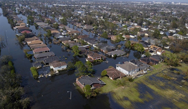
New Orleans, a city that has weathered more than its share of water worries, is getting a stark message from scientists: start planning now for a future where the Gulf of Mexico might surround it, or face chaotic displacement later.
A new interdisciplinary analysis argues that the city’s long-term fate is being shaped by three forces working together: rising seas, rapidly sinking land and the steady loss of coastal wetlands. The authors say levees and short-term engineering fixes can buy time but cannot reverse the larger coastal shift. In their view, the real choice is between a planned, multigenerational transition and a rushed evacuation driven by emergencies.
What The Paper Says
The research team, led by Tulane University geologist Torbjörn Törnqvist, published its findings this month in Nature Sustainability. The study blends geological, archaeological and demographic evidence to trace how the coastline is likely to evolve over very long time scales.
The authors describe coastal Louisiana as a kind of stress test for how far adaptation can really go in the face of land subsidence and global sea-level rise. Their bottom line is blunt: local levees and flood defenses may slow the impacts and protect people for a time, but they cannot alter the long-term inland march of the shoreline.
Key Projections
Coverage of the paper highlights a set of stark numbers. Reporters note that southern Louisiana could eventually face roughly 3 to 7 meters, about 10 to 23 feet, of global sea-level rise and could lose an estimated three-quarters of its remaining coastal wetlands. In some modeled futures, that combination would push the shoreline tens of miles inland.
As reported by The Guardian, the analysis suggests the Gulf shoreline could move 60 to 100 kilometers, about 37 to 62 miles, along certain climate and policy pathways. The authors emphasize that the timing of these shifts is uncertain. Co-author Jesse Keenan has told reporters that when it comes to practical decision-making, the planning window is most likely measured in decades rather than centuries.
Policy Context
The paper sets those projections against recent policy moves that have limited efforts to rebuild protective wetlands. In particular, it points to the cancellation or stalling of major sediment-diversion projects intended to use Mississippi River sediment to create new land along the coast.
The high-profile Mid-Barataria sediment-diversion project, designed as a flagship restoration effort, was effectively shelved last year after years of debate. As reported by WAFB, critics argue that walking away from large diversions shrinks the remaining window to build land, which in turn makes it more urgent to prepare for relocation.
What Researchers Recommend
The authors are not calling for people to pack up overnight. Instead, they argue for long-term, rights-based planning that looks several generations ahead. That means identifying sending zones where people are likely to move from, receiving zones where they could move to, and investing in infrastructure farther from the coast so communities have realistic options.
They also insist that any relocation strategy must prioritize equity, livelihoods and culture. Co-author Jesse Keenan has said the goal is to avoid a disorderly, market-driven exodus and to give Louisiana what he calls a "first-mover" advantage in climate adaptation, a point he elaborated in an interview with WBUR. The paper stresses that meaningful planning has to be participatory, with communities helping shape decisions that will affect where they live, work and maintain cultural ties.
Local Planning And Next Steps
Some groundwork for this kind of long-range thinking is already in place. The City of New Orleans updated its Hazard Mitigation Action Plan in 2026 and opened a public review period to weave newer risk information into both mitigation priorities and capital projects.
That city plan links hazard mitigation goals to actual funding decisions and recommends that coastal risk be built into broader land-use and infrastructure choices, rather than handled as an afterthought. Turning the new study’s recommendations into real programs, however, would require coordinated action across state, federal and local agencies, particularly on housing, transportation and workforce policy.
Local Coverage And Reaction
National reporting on the study has landed with a thud in New Orleans and along the coast, prompting sharp reactions. Some advocates warn that a poorly managed relocation effort could tear at the city’s cultural fabric. Others argue that the only way to avoid that outcome is precisely to start planning early, with communities leading the conversation.
Local broadcasters and regional newspapers have amplified the story, adding their own angles and commentary. A syndication of the coverage has appeared through outlets including KTUL, which laid out the researchers’ main recommendations and published imagery that underscores the stakes.
For now, the debate is centered on how elected leaders will respond. Will the paper become a catalyst for methodical, long-term transition planning, or will it be treated as one more reason to double down on efforts to hold the shoreline where it is for as long as possible?


