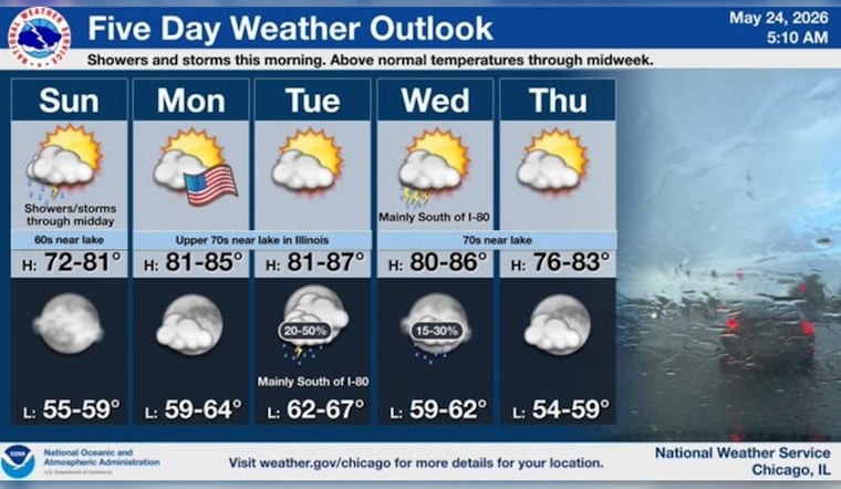
By early Sunday at 5:35 a.m. CDT on May 24, 2026, Midway Airport was already reporting a gray and damp start, with cloudy skies, temperatures around 63°F, and southerly winds near 15 to 17 mph. Showers and thunderstorms are expected through the late morning, with the steadiest rain before 1 p.m. and the best chance for heavier downpours across neighborhoods east of I-55. Brief but intense bursts of rain could quickly put standing water on poorly drained streets during the morning commute.
Morning Downpours, Watch For Ponding
The main issue early on is short-lived but heavy rainfall that can trigger localized ponding, with new totals of roughly a quarter to a half inch likely and a few spots picking up more in a hurry. Coverage should fade from west to east by midday, but areas along and east of I-55 will hang onto the most persistent showers and any rumbles of thunder. Widespread flash flooding is not expected; however, the National Weather Service notes that brief intense downpours could sharply cut visibility and lead to ponding on low-lying roads. Check the National Weather Service for the latest statements and radar.
What This Means For Your Commute
Plan on a slower go for the morning rush. Surface streets may see standing water in usual trouble spots, and some ramps and underpasses could be splashy. Transit typically runs through the rain, but delays are common when storms roll through, so it is worth checking CTA alerts before heading out and building in some extra time. Cyclists should expect slick rails, metal plates, and painted crosswalks; if your schedule allows, consider pushing that bike commute to later in the morning once the heaviest rain moves out.
Afternoon And Memorial Day Outlook
Conditions should steadily improve through the day. By afternoon, skies are expected to turn partly sunny with a high near 68°F as winds swing around to the north-northeast and ease back. Monday, Memorial Day on May 25, looks dry and warmer with highs in the mid to upper 70s, offering a much better setup for outdoor plans after the soggy start to the weekend. Looking beyond the holiday, there are signs of a modest return of shower chances inland by midweek.
Bottom line: grab the rain gear for the morning, slow down where water collects, and expect a noticeable turnaround into the afternoon, with a mostly comfortable and dry Memorial Day on tap. For real-time radar and transit updates, keep tabs on the National Weather Service and CTA alerts.


