Mother Nature did not care about your Monday night plans.
Strong storms barreled into the Chicago area Monday evening as a sharp cold front slid east into northwest Indiana, firing off severe thunderstorm warnings across the suburbs. The line of storms brought heavy downpours, frequent lightning and gusty winds that snarled flights and sent Cubs fans diving for cover at Wrigley Field. Forecasters expected most of the action to move out shortly before midnight, with some pockets of rain possibly hanging on into Tuesday morning.
An outlook from the Chicago/Romeoville office of the National Weather Service warned of damaging wind gusts that could locally reach 50 to 60 mph, along with localized minor flooding and the potential for small hail across parts of northeast Illinois and northwest Indiana. The tornado threat was labeled low but not zero, and residents were urged to keep an eye on watches and warnings as the front swept through. Forecasters noted that the window of elevated risk would be short-lived but could still pack a punch in spots.
Flights, Games And The Commute
Live coverage from FOX 32 Chicago tracked severe thunderstorm warnings for LaSalle, Will and LaPorte counties as the line raced east. The station reported that a ground stop at O'Hare International Airport disrupted arrivals and departures into the early evening, creating the kind of ripple effect frequent flyers know all too well.
On the North Side, the Cubs tried to stay one step ahead of the radar, moving Monday's first pitch up to 6:10 p.m. CT because of the forecast. The game still ended up in a weather delay once the storms arrived. According to the Chicago Sun-Times, fans and travelers were warned to expect slow pick-ups and backups near Wrigley Field and along the airport corridors as the storms rolled through.
Timing And Temperatures
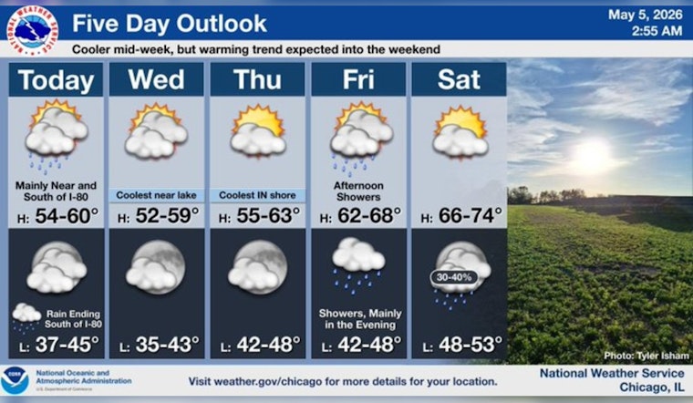
Forecasters said the bulk of the storms should clear the area before midnight, with showers possibly returning around daybreak Tuesday as cooler air filters in behind the front. The NWS forecast discussion called for temperatures to tumble roughly 20 to 25 degrees on Tuesday, with highs generally in the mid to upper 50s and lakefront neighborhoods running a few degrees cooler. In other words, that quick taste of summer is on hold for a bit.
Safety And Travel Tips
Damaging wind gusts remained the primary concern, since they can knock down tree limbs and trigger localized power outages. Residents were urged to secure loose outdoor items and be ready for brief interruptions in service. Drivers were reminded to avoid flooded streets, since stalled vehicles are a surprisingly common reason for water rescues during heavy downpours, and to build in extra travel time for both airport runs and the regular commuter grind.
FOX 32 Chicago emphasized those practical steps in its Monday evening coverage, underscoring that a little patience and preparation can go a long way when the weather turns fast and noisy.
Keep wireless alerts enabled on your phone and follow local watches and warnings until the system moves out. This story will be updated if officials issue new advisories or if conditions take a turn.


