A fast-moving severe thunderstorm warning clipped parts of northern Siskiyou County on Wednesday evening, with radar showing a cell capable of damaging winds and hail pushing across the Highway 97 corridor. The alert arrived with little lead time for rural communities and popular camp spots, prompting officials to urge motorists and campers to seek shelter and avoid unnecessary travel while the storm moved through.
Where the Warning Was in Effect
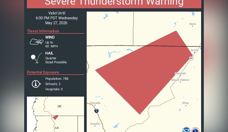
The updated warning, issued around 4:36 p.m. and valid until 5:15 p.m., named Dorris, Mount Hebron, Macdoel, Juanita Lake Campground, Deer Mountain Snow Park and stretches of Highway 97 as being in the path, according to The Sacramento Bee. That report cites the National Weather Service in Medford, which said the storm was located near Dorris, about 22 miles south of Klamath Falls, and was moving southwest at roughly 35 mph. Local forecasters warned that accumulated hail could make roads slick and that unsecured outdoor objects could be blown around by strong gusts.
Why the Storm Matters
The National Weather Service notes that thunderstorms produce roughly 20 to 25 million lightning flashes that strike the ground in the U.S. each year and that lightning kills an average of about 20 people annually, according to the National Weather Service. The Medford advisory that prompted the Sacramento Bee update described the storm as radar-indicated with the potential for 60-mph gusts and quarter-size hail and said, “Expect damage to roofs, siding, and trees,” according to the National Weather Service in Medford. Those hazards can make brief but intense storms particularly dangerous in thinly populated areas that have few sheltered public spaces.
Local Alerts and Safety Steps
Siskiyou County encourages residents to sign up for county alerts and to follow local public-safety channels. The county’s ReadySiskiyou portal lists how to get notifications and provides contact information for the Office of Emergency Services. If you are outdoors during a storm, officials advise seeking a sturdy building or vehicle and avoiding open fields, ridgelines and isolated trees. Drivers are urged to slow down, switch on headlights and avoid driving through flooded or hail-covered stretches of roadway.
Where to Watch for Updates
For the latest watches, warnings and radar-based information, residents are encouraged to check the National Weather Service in Medford and local emergency pages. County and NWS sites will post any extensions, cancellations or additional instructions as conditions evolve. Local officials remind residents that in fast-moving events the situation can change quickly and that even short-duration advisories should be taken seriously in areas with limited shelter options.


