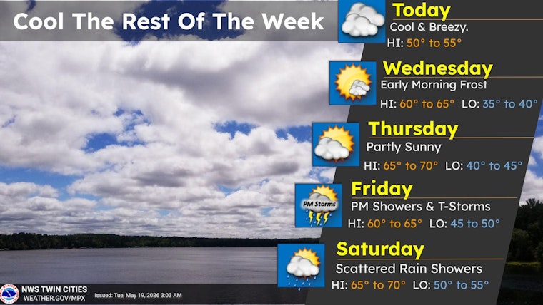
Clouds and a stiff northwest breeze are giving Minneapolis a raw start to Tuesday, with Minneapolis–Saint Paul International Airport reporting about 50°F at 5:35 a.m. CDT on May 19, 2026. Northwest winds around 15 mph are gusting to near 30 mph, and the high today is expected to top out near 54°F with a chance of brief, spotty showers after 1 p.m. If you are out on exposed bridges, bike lanes or patios, it will feel colder than the thermometer lets on.
Afternoon Gusts And Quick Showers
Northwest winds of 5 to 15 mph with gusts up to 30 mph are likely through mid-afternoon, with the best shot at showers after 1 p.m. Any rain should be brief and scattered, but roads could turn slick for a short time where showers pass, so an umbrella in the bag is not a bad idea. According to the National Weather Service Twin Cities, winds should ease this evening as skies clear out.
Nighttime Cooling And Frost Risk Outside The City
With skies expected to clear after sunset, temperatures will tumble into the low 40s across the metro and into the 30s in rural, low-lying areas, bringing a chance for patchy frost away from the city core. Downtown Minneapolis’ urban heat island should keep a hard freeze at bay, but suburban and rural gardeners will want to cover tender plants overnight.
Weekend Warmup And Memorial Day
Temperatures rebound Wednesday into the 60s, then climb into the 70s and low 80s by Sunday and Memorial Day, with a high near 84°F currently on tap for Monday, May 25. Shower and thunderstorm chances return Friday into the holiday weekend, mainly late Friday night into Saturday morning, and the overall severe risk looks low, though outdoor plans should still come with a backup option. For more on how the pattern shapes up later in the weekend, see Minneapolis basks in sun, braces for storms.


