North Carolina officials are telling residents to put the matches away on Thursday, warning that a stretch of dry, breezy weather has set the stage for fires to catch and spread fast. In a late Wednesday alert, state emergency managers urged people to postpone outdoor burning and to fully extinguish smoking materials. They say a few simple choices, like skipping burn piles and making sure cigarettes are dead out, could be the difference between a quick scare and a full‑blown wildfire.
🔥🔥 High Fire Danger Tomorrow (Thursday)!
— NC Emergency Management (@ncemergency) June 18, 2026
Be Alert. Postpone Burning. Extinguish smoking materials. Do your part.
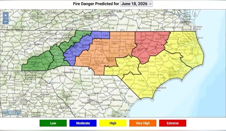
Map from @ncforestservice
#ReadyNC https://x.com/i/status/2067419176210223537
The post on X from NC Emergency Management included a color‑coded fire danger map credited to the N.C. Forest Service and the blunt message: “Be Alert. Postpone Burning. Extinguish smoking materials,” according to NC Emergency Management. The short bulletin emphasized that the risk will peak on Thursday and asked residents to keep burn piles and discarded smoking materials away from woods, fields and ditches. Officials stressed that the advisory is preemptive and is meant to cut down on human‑caused ignitions on a high‑risk day.
Where the map flagged risk
The interactive map used by state agencies shows “High” and “Very High” fire danger ratings across the Triangle and much of the coastal plain, including labels for Raleigh, Fayetteville, Jacksonville and Wilmington, with the elevated zone stretching toward the Virginia Beach area. The fire portal from the NC State Climate Office explains how those ratings are calculated from local weather and fuel‑moisture data and lets residents click into their Fire Danger Rating Area for a seven‑day outlook. Because the map relies on both modeled and observed inputs, officials note that local conditions may differ, and residents are encouraged to check county specifics before burning.
Why conditions are risky
Forecasters point to a mix of low humidity, warm temperatures and gusty winds that makes it easier for small fires to build intensity and spread, especially where fuels have been drying for weeks. Fire‑weather products from the National Weather Service for central and eastern North Carolina outline those thresholds and recommend delaying any open burns when ratings reach High or higher. Fire crews say that combination of receptive fine fuels and wind is their biggest concern on a day like Thursday.
What officials advise
The N.C. Forest Service, which issued a statewide open‑burning ban in late March and canceled permits in many areas, warns that “vegetative fuels will dry rapidly” under the current pattern and urges residents to postpone yard and land‑clearing burns; see the N.C. Forest Service March 28 press release for details. For local permitting rules and information on how to request a burn permit where it is allowed, residents are directed to the N.C. Forest Service open‑burning permits guidance at ncagr.gov. Officials say anyone who sees smoke or an unplanned fire should call 911 right away.
Where to get updates
Residents are urged to keep an eye on official channels for any new watches or local changes to burn bans. State officials point people to ReadyNC for statewide advisories, while county emergency management pages carry local decisions. The National Weather Service’s fire‑weather products provide forecast conditions, and local fire marshals and county emergency management offices remain the go‑to contacts if there is any doubt about whether burning is allowed. Staying plugged into those sources, officials say, is key to avoiding accidental ignitions during a high‑danger day.


