Minneapolis rolled into Wednesday under a soft gray veil, with patchy fog clinging to streets and runways and temperatures near 60°F. Visibility around MSP dropped enough to slow some early commutes, with drivers slipping in and out of brief pockets of thicker fog that will lift once the sun gets to work.
The National Weather Service issued a Special Weather Statement early Wednesday, flagging patchy, at times dense fog with visibility dropping to a quarter mile in some spots. Forecasters added that the fog layer is shallow and should burn off quickly after sunrise. Drivers are urged to ease off the gas on bridges and overpasses and stick with low-beam headlights, according to the National Weather Service Twin Cities.
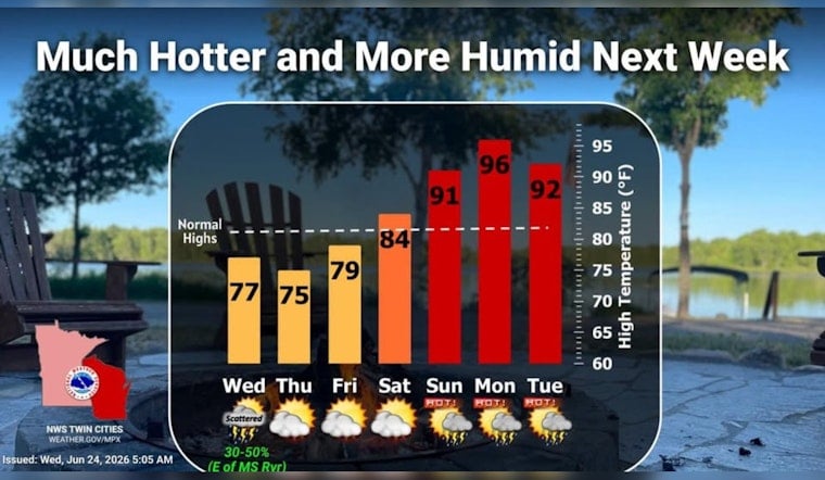
After the fog clears, Wednesday shapes up partly sunny with a few isolated showers and daytime thunderstorms possible, with highs near 77°F and west winds that could gust up to about 15 mph. Rain chances look scattered and on the low side, but any storm that pops could drag in a quick burst of heavy rain and gusty winds, especially from late afternoon into early evening.
Afternoon Showers And Gusts
Any storm that develops this afternoon may bring sudden downpours, lightning, and brief ponding on roads where rain hits hardest. If you are planning to be outside, keep an eye on radar and have a quick path to shelter ready, since coverage will be spotty from neighborhood to neighborhood.
Weekend Heat Spike
The overall pattern flips as the weekend approaches. Forecasters expect temperatures to climb sharply, with highs near 91°F on Sunday and readings pushing into the mid-to-upper 90s on Monday across parts of the Twin Cities metro. Rising humidity will join the party, with dew points heading into the low-to-mid 70s and heat indices on Monday projected to land in the mid-100s. The National Weather Service notes that combination as potentially dangerous for anyone working or spending long stretches outside.
Plan Ahead
For the fog, the advice is basic but effective: slow down this morning, use your headlights, and pad your commute time. Looking ahead to the heat risk later in the weekend, Hennepin County offers a brief guide and map of cooling locations for anyone who needs a safe, air-conditioned spot during high heat; local libraries and community centers are a good place to start, according to Hennepin County.
Forecast details will be updated if advisories change. Hoodline shared a June 21 update on the cool start to this week, and this latest local check-in zeroes in on Wednesday morning’s dense fog and the developing heat threat for Sunday and Monday.


