By 5:35 a.m. CDT Friday, June 19, 2026, the day was already off to a noisy start in Oklahoma City. Will Rogers World Airport was reporting mostly cloudy skies and a mild 68°F, but the real story was unfolding to the southwest. Thunderstorms were bubbling up across southwest Oklahoma and western North Texas, setting the stage for heavy downpours and frequent lightning through the early morning hours.
Morning Storms And Flood Watch
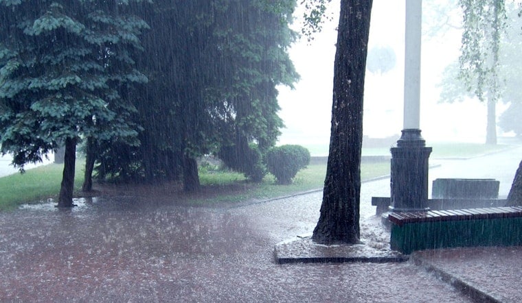
A Flood Watch is in effect for parts of southwest Oklahoma and western North Texas into the morning, with storm coverage expected to peak before mid-morning. Many neighborhoods are looking at about an 80% chance of rain. Some of these storms could unload quick bursts of heavy rain that lead to ponding on city streets, along with frequent lightning and isolated large hail, according to the National Weather Service Norman.
Commute And Juneteenth Plans
The morning commute will likely slow down wherever those downpours roll through, as visibility drops and water collects in low spots. If you have early travel plans, it is worth building in extra time. Outdoor Juneteenth events that kick off before noon should have a backup plan ready to go. The silver lining: many scheduled activities later in the day may catch a break, since conditions should trend drier once the storms slide east.
Through The Weekend
Storms are expected to taper from northwest to southeast by early to mid-afternoon, with highs topping out near 83°F today. Saturday looks mostly dry, with afternoon temperatures in the mid-80s. By Sunday, the heat is back, with highs near 96°F and a renewed threat for strong to severe storms late Sunday into the evening. Forecasters caution that the late-week pattern is likely to deliver another round of heavy rain and strong winds, per the National Weather Service Norman.
Practical Tips
If you come across standing water on the road, remember the rule: turn around, do not drown. Never drive through flooded streets, no matter how shallow they look. Head to a sturdy shelter if lightning is nearby, keep phones charged so you can receive weather alerts, and check radar before you hit the road or set up any outdoor gear.
For more context on this active pattern, see our earlier coverage of the metro's soaked-then-scorched swings. We will update this post if watches or warnings change through the morning.


