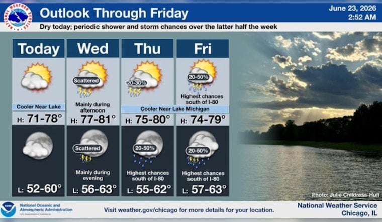
Chicago woke up to a cool, lake-cooled start Tuesday, with early readings near 55°F at Midway and a north-northeast breeze keeping lakeshore neighborhoods a few degrees chillier than spots farther inland. Skies are expected to stay mostly sunny today, with a comfortable high near 71°F that feels like a brief calm before the midweek pattern takes a turn.
What To Expect Today Through Wednesday
This afternoon should stay mostly sunny with north-northeast winds around 5-10 mph and an overnight low near 60°F. A mid-level trough and an approaching surface low are lined up to bring a chance of showers and thunderstorms on Wednesday, with storms most likely in the afternoon and evening. Gusts could reach up to 20 mph, and a few storms may strengthen enough to become strong, according to the National Weather Service.
Lakefront Versus Inland
A light onshore flow will keep beaches and lakefront neighborhoods noticeably cooler, with temperatures holding in the low 70s near the lake while readings climb higher just a few miles inland. There are no active watches or warnings for the area this morning, but any late-day storms could bring localized downpours and gusty winds that briefly tangle up the commute or cut short outdoor plans.
Looking Ahead And Preparedness
Temperatures are expected to trend upward late this week and into early next week, with highs climbing into the 80s this weekend and a stronger warm-up by next Monday when some inland spots could approach the low 90s. If the heat arrives as forecast, the city publishes public cooling locations and fieldhouses, which are listed on the City of Chicago cooling centers map, or you can call 311 to find a nearby site.
Plan Ahead
It is a good idea to have a backup plan for any outdoor gatherings Wednesday afternoon and evening and to secure lightweight furniture before storms move in. Keep your phone charged for weather alerts and take a quick look at the forecast before heading out.


