Raleigh did not get a gentle wake-up call Friday. The day started soggy, with rain and patchy fog before sunrise, temperatures hovering near 72°F, and visibility knocked down on roads across the area. Showers and thunderstorms are expected to hang around through midday Friday, June 19, 2026, with some storms packing heavy downpours and gusty winds. The good news: the bulk of the rain should slide out by early afternoon, with skies clearing and highs climbing into the upper 80s.
Timing And Hazards
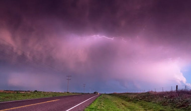
The National Weather Service Raleigh expects widespread showers through mid-morning, with stronger storms embedded in the mess. Those stronger cells could produce damaging wind gusts and, in isolated cases, a tornado, with the greatest risk across the southern Piedmont and Sandhills.
Forecasters are also flagging the potential for heavy rain along a relatively narrow corridor. Local totals of 1 to 2 inches are possible, and model guidance points to a swath of 2 to 4 inches across parts of the Piedmont. That kind of quick-hit rainfall can trigger localized flooding in poor-drainage spots and urban areas. If you are driving through heavy rain, slow down, leave extra space, and be ready for sudden ponding on the road.
Afternoon And Weekend Outlook
Rain should taper from west to east by early afternoon, opening the door to partly to mostly sunny skies and afternoon highs near 87 to 89°F. Saturday looks mostly sunny with a high near 89°F.
The heat cranks up Sunday, with highs forecast to reach the mid 90s. Monday is expected to be even hotter, with temperatures again in the mid 90s and an increased chance of late-afternoon storms. Heat indices could top 100°F Monday afternoon, so any outdoor plans will need extra water, shade, and breaks from the sun.
Juneteenth Events And The Commute
With many Juneteenth events on the calendar across the Triangle today, organizers and attendees face a tricky morning window. Expect wet roads, slower traffic, and the possibility of travel delays during the morning commute as showers and storms move through.
Heavier pockets of rain could briefly flood streets and further reduce visibility, so allow extra time, take it easy at the wheel, and avoid low-lying routes that tend to collect water. If a parade or outdoor ceremony is scheduled for late morning, organizers may want to line up an indoor option or plan for a delay until storms have cleared the area.
Safety Tips
If thunderstorms approach, head indoors to a sturdy building and stay away from windows. Do not drive through standing water, even if it looks shallow. Secure loose outdoor items before the storms arrive, and keep a phone or battery-powered radio handy for updates from local authorities.
This forecast updates our previous outlook on the earlier heat and storm outlook. We will post more information if watches or warnings are issued and as conditions evolve through the day.


