Thunder and rain kicked off Tuesday, June 30, 2026, in Minneapolis as a line of light showers and noisy storms pushed across the metro before sunrise. By dawn, Minneapolis–St. Paul International (KMSP) was already near 79°F, and brief heavy downpours left slick roads for the morning commute while showers and embedded thunderstorms raced northeast through the area.
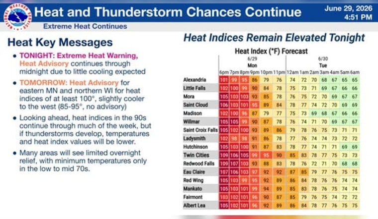
Showers and thunderstorms are likely before 8 a.m., and a fast-moving complex could still whip up damaging wind gusts of 50–60 mph across parts of southern Minnesota, with 30–40 mph gusts possible around the Twin Cities. Skies are expected to clear by late morning, but a Heat Advisory is in effect until 9 p.m. CDT, with highs near 91°F and heat index readings of about 95–100°F this afternoon, according to NWS Twin Cities.
Cooling Options And Safety
If you need air conditioning, local organizations have opened cooling sites. The Salvation Army says its Twin Cities service centers across Minneapolis, Brooklyn Park and St. Paul are available during normal hours, as reported by Twin Cities service centers. Drink plenty of water, avoid heavy outdoor work during the hottest part of the day, and keep an eye on older adults or anyone who does not have access to AC.
What To Expect This Week
Another round of showers and thunderstorms is possible Wednesday morning, with highs easing into the upper 80s for midweek and nighttime humidity sticking around. Scattered storm chances linger through the July 4 weekend, so it is worth having indoor backup plans for outdoor events and checking updated forecasts before you head out.


