New Orleans woke up in a steam bath Thursday, with fog hanging over the city, Lakefront readings in the low 80s and dew points parked in the upper 70s. A Flood Watch covers much of the metro through Friday morning, June 19, 2026, and forecasters warn that multiple rounds of heavy, tropical-style downpours today and tonight could trigger life-threatening street and creek flooding. Once the storms finally back off, the weekend flips straight to oppressive heat, with highs in the low 90s and heat-index values expected to top 110F.
Afternoon Downpours And Flash-Flood Danger
Showers and thunderstorms are likely Thursday afternoon into tonight, with south winds around 15 to 20 mph and gusts up to 35 mph. Any one storm could unload a quick, blinding downpour, the kind that turns intersections into lagoons in minutes and snarls traffic across the city.
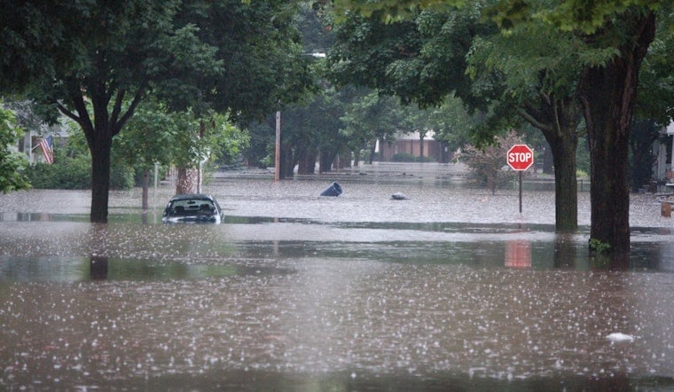
Forecasters say widespread rainfall totals of 3 to 6 inches are possible across parts of southeast Louisiana through tonight, with a narrow stripe of 6 inches or more where storms repeatedly track over the same areas. That setup is described as “particularly dangerous and life threatening,” and residents should be ready for flash-flood warnings, according to the National Weather Service.
Juneteenth And Weekend Heat
Friday, June 19 (Juneteenth) is expected to start off mostly sunny, with a chance of showers and thunderstorms after about 1 p.m., and highs near 91F. Heat-index values could climb to around 111F in some neighborhoods, and forecasters say Heat Advisories are likely for portions of the area over the weekend.
Overnight lows will struggle to drop into the low 80s, which means very little relief after dark for festivals, parades and other outdoor events. If you are planning to celebrate outside, this is one of those weekends where shade, water and frequent breaks are not optional.
Boaters, Commutes And Safety Tips
On the water, small craft advisories and hazardous onshore winds are in effect for coastal areas, with choppy seas and gusts near 30 knots offshore that can make small-boat travel outright dangerous. This is not a great time to test how well your trolling motor handles whitecaps.
On land, expect ponding on low-lying streets and delays whenever the heaviest bands roll through. Never drive through flooded roads, even if you “know the street,” and move vehicles to higher ground if possible before storms arrive. Keep a battery-powered radio or phone alerts handy and be prepared to follow any Flash Flood Warning instructions from local officials.
Hoodline Update
We first flagged this soggy setup on June 16, and this morning’s update is a significant escalation, as forecasters now stress a higher, life-threatening flash-flood risk. For background on how we got here, see our earlier look at daily drenchers and flood fears all week.
Bottom Line
If you have outdoor plans today or Juneteenth events on Friday, seriously consider shifting them indoors and building in extra time for travel. Keep an eye on local alerts and updates from the National Weather Service for Flash Flood Warnings and marine advisories before you hit the road or the water.


